Available with Business Analyst license.
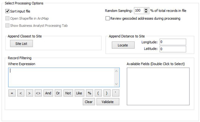
The Processing options tab allows you to specify several functions that affect how your file is processed.

- Sort Input File
Allowing Address Coder to sort your file by ZIP Code or City greatly increases the speed at which the file is processed compared with the same file that has the addresses in a random order. This is strongly recommended.
- Site List
You may supply a list of sites to Address Coder and it will determine the closest site to each record you process. This file must be in comma-delimited format and contain three fields: an ID, Longitude, and Latitude. This function can add extra overhead to processing each record and slow overall processing speed.
- Random Sampling
You can specify the percentage of the file you want sampled. (100% = process the entire file)
- Open Shapefile in ArcMap
If you have Esri's ArcMap installed, you can open the shapefile it created using ArcMap once processing is complete. This option is ignored when jobs are run in batch mode.
- Show Business Analyst Processing Tab
If you have ArcGIS with Business Analyst installed and are creating shapefile output, you can have Address Coder show the Business Analyst tab for more processing options. Creating Business Analyst output requires that the files be stored in a predetermined location with specific names. These names can't be edited.
- Review geocoded addresses during processing
Displays the address that was just processed and allows you to make corrections.
- Append Closest to Site
If you have a list of sites and would like to know the which site is closest to each of the records you are processing you can specify a comma delimited file with 3 columns, ID, longitude and latitude. Address Coder will then use this file to append the ID of the site closest to each record.
- Append Distance to Site
Address Coder allows you to append a distance from a specified site to each record. You can specify the location of this site by entering the Longitude and Latitude (if known) or click Locate and enter the address to allow Address Coder to determine the location. To then use this location, you also need to select Distance to Site from the Basic Variables list on the Data Items tab.
- Record Filtering
Here, you can construct a logical Where expression to extract some subset records from your file for processing. Any change made to the Where Expression box will require you to click Validate. This will verify the syntax of your expression and, if valid, inform you of the number of records you will process. Use the single quotes around any text value, for example, STATE = 'CA'. To add a field to the Where Expression double click on the field name in the list box ( Available Fields (Double Click to Select)) to the right.