ArcGIS Desktop

  • ArcGIS Pro
  • ArcMap

  • My Profile
  • Help
  • Sign Out
ArcGIS Desktop

ArcGIS Online

The mapping platform for your organization

ArcGIS Desktop

A complete professional GIS

ArcGIS Enterprise

GIS in your enterprise

ArcGIS Developers

Tools to build location-aware apps

ArcGIS Solutions

Free template maps and apps for your industry

ArcGIS Marketplace

Get apps and data for your organization

  • Documentation
  • Support
Esri
  • Sign In
user
  • My Profile
  • Sign Out

ArcMap

  • Home
  • Get Started
  • Map
  • Analyze
  • Manage Data
  • Tools
  • Extensions

Setup distance measurement

  • Distance measurement

Distance measurement

The size of the territory is defined from the center of the territory to its borders. This distance can be calculated using the following methods:

  • Straight line – a geometrical difference between coordinates of points between the center and its borders.
  • Network distance – a distance that is calculated taking into account the movement on a transport network.
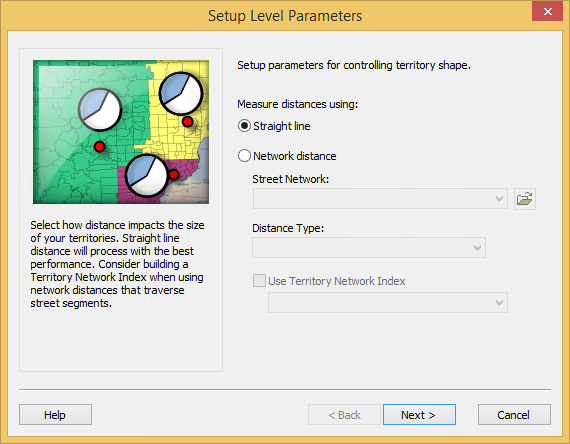
Distance measurement page of the Setup Level Parameters wizard

Distances, when calculated using Straight Line, are fast and suitable for a rough estimate of territory allocation as they relate to one another. Using network distances for calculations are more accurate but slower.

Note:

You can use a Territory Network Index to improve the performance of distance calculations.

ArcGIS Desktop

  • Home
  • Documentation
  • Support

ArcGIS

  • ArcGIS Online
  • ArcGIS Desktop
  • ArcGIS Enterprise
  • ArcGIS
  • ArcGIS Developer
  • ArcGIS Solutions
  • ArcGIS Marketplace

About Esri

  • About Us
  • Careers
  • Esri Blog
  • User Conference
  • Developer Summit
Esri
Tell us what you think.
Copyright © 2022 Esri. | Privacy | Legal