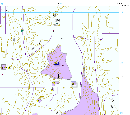
Military Grid Reference System (MGRS) values can be calculated for the Guide to Numbered Features (GNF) and Transportation annotation feature classes. This value is a combination of the column and row number in which the annotation is located. The ICM MGRS Calculator tool calculates the value based on the location of the annotation in the grid. For instance, the 70 annotation feature has an MGRS value of 8621, while the 76 annotation feature has an MGRS value of 8521.

With the ICM MGRS Calculator tool, either new MGRS values can be generated or existing values can be updated.
The MGRS value is used as a reference in the ComplexOutline_A feature class and corresponds with the Grid Reference number found on the Guide to Numbered Features element. It is also used with the Streets Index element to indicate which cell contains a road. Both of these are required elements for an Image City Map (ICM) product and require this information.
- Start ArcMap.
- Add ICM data to the map, ensuring that the ComplexOutline_A feature class is included.
- Add the ICM MGRS Calculator tool by doing the following:
- On the main menu, click Customize > Customize Mode.
The Customize dialog box appears.
- Click the Commands tab.
- In the Categories list, click Defense Mapping.
- Click and drag the ICM MGRS Calculator button
 from the Commands list to a toolbar.
 - Click Close.
- On the main menu, click Customize > Customize Mode.
- On the main menu, click Customize > Toolbars > Production Editing.
- Click the Production Start Editing button
 on the Production Editing toolbar.
- Choose the GNF_anno_[scale] feature class in the table of contents.
- Click the ICM MGRS Calculator button
 .
.The ICM MGRS Calculator message box appears once the processing is complete.
- Click OK.
- Repeat steps 6–8 with the Transportation_anno_[scale] feature class.