Available with Production Mapping license.
There are times when it is more efficient to work with more than one product at a time, or when other processes within ArcGIS Desktop may require access to the products outside the product library.
You can access products in batch to put on disk to allow the data and map document to be manipulated using arcpy or other processes. One common workflow is to use the arcpy mapping module to batch print or export the map documents that are stored in the product library.
- Start ArcMap.
- If necessary, open the Product Library window by clicking Customize > Production > Product Library on the main menu.
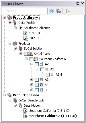
A tree view of the product library appears.

- Expand Product Library and Products.
- Navigate to the series that contains the products you want to check out.
- Right-click the series and click Batch Manage Products.
The Batch Manage Products dialog box appears.
- Confirm that the series contains the products you want to manage.
- Click the Action drop-down arrow and choose Check Out.
- Check the check box for each product you want to check out from the Available Products list.
- Click OK.
The Check Out Product dialog box appears.
- Click the ellipsis (...) next to the Output Location field.
The Browse For Folder dialog box appears.

- Navigate to the folder to which you want to check out the products.
- Click OK.
The Open file option is not enabled when these actions are performed in batch.
- Uncheck the Overwrite existing file(s) check box if a previous version of the .mxd exists in the location you chose and you do not want to overwrite this file with the version from the product library.
If you don't check this check box and you have a local version, the local version is used instead of the one from the product library.
- If template instructions exist and were set, and you want to use them, click Options.
A dialog box appears with a list of template instructions.
- Check the box next to the template instructions that you want to apply.
- Data Frame Rules: Allow products to have their data frame settings, such as scale, extent, coordinate system, and rotation, updated based on a product's associated instance.
- Layout Rules: Enable a product map document’s layout size and orientation and the relative placement of elements on that layout to react to changes that happen on dynamic cartographic products.
- Python Scripts: Allow custom business logic to be executed on a product. A single Python file can be saved as part of a template instruction.
- Click OK.
- Click OK to check out.
The Checking Out Product progress dialog box appears.

Checking Out Product dialog box with progress information - Click OK when the process completes.