ArcGIS Desktop

  • ArcGIS Pro
  • ArcMap

  • My Profile
  • Help
  • Sign Out
ArcGIS Desktop

ArcGIS Online

The mapping platform for your organization

ArcGIS Desktop

A complete professional GIS

ArcGIS Enterprise

GIS in your enterprise

ArcGIS Developers

Tools to build location-aware apps

ArcGIS Solutions

Free template maps and apps for your industry

ArcGIS Marketplace

Get apps and data for your organization

  • Documentation
  • Support
Esri
  • Sign In
user
  • My Profile
  • Sign Out

ArcMap

  • Home
  • Get Started
  • Map
  • Analyze
  • Manage Data
  • Tools
  • Extensions

Viewing selected feature attributes

Available with Production Mapping license.

You can limit the number of fields to display when defining a data source and table fields for a graphic table element. You choose fields to display in the Defining table fields dialog box. Any field not chosen in this dialog box will not appear in the Data Items dialog box.

You can use the Identify source feature dialog box to display all fields from a data source. This dialog box displays all attributes and values from a selected data item. You can also use this dialog box to flash a feature's location on the map display area.

  1. Start ArcMap.
  2. Load data in the map if necessary.
  3. Verify that you are in layout view if necessary.
  4. Right-click the graphic table element and click Properties.

    The Table Properties dialog box appears.

  5. If necessary, click the Data Source tab.

    The Data Source tab appears.

    Data Source tab
  6. Click Data Items on the Data Source dialog box.

    The Data Items dialog box appears.
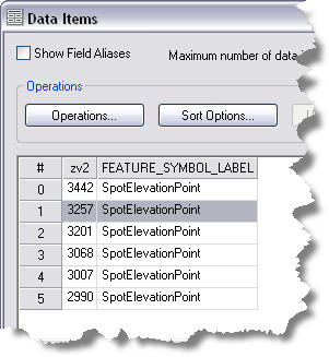
    Data Items dialog box
  7. Right-click a table cell and click Identify Source Feature.

    The Identify source feature dialog box appears.
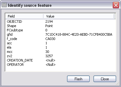
    Identify source feature dialog box
  8. If necessary, click any field and click Flash to flash that feature on the map display area.
  9. Click Close.
  10. Click OK.

    The Table Properties dialog box appears.

  11. Click OK.

Related topics

  • What is a graphic table element?
  • A quick tour of the graphic table element

ArcGIS Desktop

  • Home
  • Documentation
  • Support

ArcGIS

  • ArcGIS Online
  • ArcGIS Desktop
  • ArcGIS Enterprise
  • ArcGIS
  • ArcGIS Developer
  • ArcGIS Solutions
  • ArcGIS Marketplace

About Esri

  • About Us
  • Careers
  • Esri Blog
  • User Conference
  • Developer Summit
Esri
Tell us what you think.
Copyright © 2021 Esri. | Privacy | Legal