Available with 3D Analyst license.
The raster cell size selected for a study area depends on the cell size required for the most detailed analysis. The cell must be small enough to capture the required detail but large enough so computer storage and analysis can be efficient. The more homogeneous an area is for critical variables, such as topography and land use, the larger the cell size can be without affecting accuracy.
Before specifying the cell size, the following factors should be considered:
- The resolution of the input data
- The size of the resultant database compared to disk capacity
- How close to the data you will be when visualizing it
- The desired response time
- The application and analysis that is to be performed
A cell size finer than the input resolution will not produce more accurate data than the input data. It is generally accepted that the resultant raster dataset should be the same or coarser than the input data.
If you expect to be navigating close to the raster in ArcGlobe or ArcScene, you might need to increase the raster resolution to avoid blockiness. This is especially true when converting vector features to raster data.
Different resolutions
The ArcGIS 3D Analyst extension allows raster datasets of different resolutions to be stored and analyzed together in the same database. Since 3D Analyst provides this capability, the decisions discussed above can be made separately for each dataset rather than simultaneously for all the rasters in the database.
Raster datasets that store different types of information can be stored at different resolutions to meet the needs of the data and analysis that will be completed with the raster. A raster dataset representing a state's watershed boundaries can be stored at a coarser cell resolution than a raster dataset representing the distribution of endangered species.
When performing analysis between rasters of different cell sizes, the rasters are resampled to a common resolution, typically to the coarsest unless otherwise specified, before performing the function.
Loss of resolution
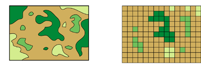
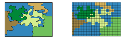
The major disadvantage of cell representation of map data is the loss of resolution that accompanies restructuring data to fixed cell boundaries. Resolution increases as the size of the cell decreases; however, cost normally also increases, both in disk space and processing speeds.
For a given area, changing cells to one-half the current size requires as much as four times the storage space, depending on the type of data and the storage techniques used. However, for most users, the efficiency of cell-based analysis more than compensates for the loss of resolution.

When resampling finer-scale data to coarser-scale data, the larger cells may encompass more than one data value from the finer-scale data. In this case, the input data must be aggregated or prioritized and each cell given a single value, thereby decreasing data resolution. The optimum cell size to capture the appropriate detail varies from study to study. The smaller the cells, the greater the resolution and accuracy; coding, database storage, and processing speed for analysis are more costly.
