Available with Spatial Analyst license.
In ArcGIS 10, all of the capabilities of Spatial Analyst are available to you through geoprocessing tools and Python.
If you are familiar with the Spatial Analyst toolbar in 9.3  and earlier releases of ArcGIS, you will notice that the toolbar in ArcGIS 10 no longer has the drop-down list of certain individual operations. There were only about 30 individual capabilities that were directly available that way, but using the geoprocessing tools instead provides full access to all 170 individual capabilities of Spatial Analyst, including 14 operations that were not available in the old Raster Calculator or Workstation Grid.
If you wish, you can customize the default Spatial Analyst toolbar by adding any specific tools you frequently use to it.
9.x Toolbar tools and their Geoprocessing tool equivalents
The following table maps the relationship between the tools available on the Spatial Analyst toolbar in ArcGIS 9.x with their corresponding Spatial Analyst geoprocessing tools in ArcGIS 10.
| 9.3 Spatial Analyst toolbar control | Geoprocessing tool equivalent | |
|---|---|---|
Distance | Straight Line Optional outputs:
| Optional outputs: |
Allocation | ||
Cost Weighted Optional outputs:
| Optional outputs: | |
Shortest Path | ||
Density | Density type:
| Equivalent: |
Interpolate to Raster | Inverse Distance Weighted | |
Spline | ||
Kriging | ||
Surface Analysis | Contour | |
Slope | ||
Aspect | ||
Hillshade | ||
Viewshed | ||
Cut/Fill | ||
Cell Statistics | ||
Neighborhood Statistics | ||
Zonal Statistics | ||
Zonal Histogram | ||
Reclassify | ||
Raster Calculator | ||
Convert | Features to raster | (In the Conversion toolbox > To Raster toolset.) |
Raster to Features | (In the Conversion toolbox > From Raster toolset.) | |
Options | General tab:
| Equivalent:
|
Extent tab:
| Equivalent:
| |
Cell Size
| Equivalent:
| |
Analysis environment
In ArcGIS 9.x, the analysis environment for the toolbar was controlled from the Options menu and was separate from the environment settings used by geoprocessing tools. This could lead to some confusion and inconsistent results for similar operations performed between the toolbar and the geoprocessing tool. ArcGIS 10 simplifies things by having only one analysis environment when running tools. Reference the geoprocessing environment settings for more information.
Finding equivalent tools from the 9.x toolbar
If you are having difficulty finding the Spatial Analyst geoprocessing tool that corresponds to a tool from the old Spatial Analyst toolbar, the Search window has been programmed to include the old names and provide you with the new equivalent.
For example, to find the equivalent for the Distance > Straight Line tool from the Spatial Analyst 9.3 toolbar, do the following:
- Click on the Search button
 or hit Ctrl+F.
 - Click on the Tools link.
- Type the name of the tool you are looking for in the search box and press Return.
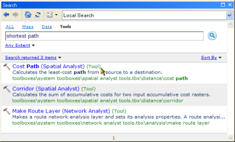
You should see the name of the tool to use in the returned list. In the following example, the Shortest Path item on the toolbar was searched on, and the first return was Cost Path, which is the geoprocessing tool equivalent of this toolbar function.

Map Algebra and the Raster Calculator
The Raster Calculator tool that was available in ArcGIS 9.x has been superseded by a new Raster Calculator geoprocessing tool in ArcGIS 10. This new tool has a similar calculator-like interface to that in the previous toolbar, allowing you to easily execute Map Algebra expressions. It can also be used in ModelBuilder in a similar way to the SOMA (Single Output Map Algebra) tool that was available in previous releases.