Available with 3D Analyst license.
Display the LAS dataset from a variety of common lidar point renderers available from the LAS Dataset toolbar.
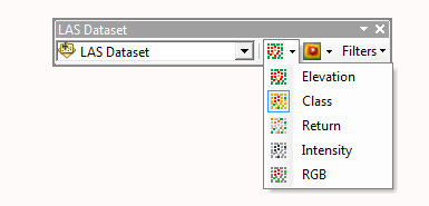
Displaying a LAS dataset as points allows you to quickly display, edit, and analyze directly on the lidar points managed in LAS files. Using the point display drop-down menu on the LAS Dataset toolbar, choose from several common lidar point-based symbology renderers.
Once a renderer is selected, the changes will automatically be applied to the LAS dataset listed in the active LAS dataset Layer drop-down menu.
The LAS dataset renderers available on the LAS Dataset toolbar are slightly different between ArcMap and ArcScene.
LAS Dataset toolbar point display options in ArcMap:

LAS Dataset toolbar point display options in ArcScene:

Select from any of the following point-based symbology renderers:
| Point Symbology | Description |
|---|---|
Display LAS points based on elevation. | |
Symbolize the LAS dataset points by the LAS classification code. | |
Symbolize the LAS dataset points by the lidar pulse return number. | |
The return strength of the laser pulse that generated the lidar point. | |
Symbolize the LAS dataset points by the RGB (red, green, and blue) bands. |