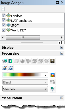
The Image Analysis window's Processing section simplifies the experience of applying complex processing and analysis techniques to layers of image and raster data in ArcMap. The tools provide one-click options to apply processes, such as clipping, normalized difference vegetation index (NDVI) creation, mosaicking, and exporting. The tools are responsive to the selected layers in the window and are activated only when the appropriate inputs for the processes are selected. More than one layer can be chosen, and using the tool applies the processing or analysis to each layer creating temporary layers in the table of contents.
The processing is applied to the raster, mosaic dataset, image service, or WCS layers on the fly. The original data remains unaltered, with the results added as new temporary layers to the data frame. This is because all the processing tools output a new temporary raster layer that uses functions to process the data. Functions allow the processing to be applied quickly and on the fly rather than creating another data file (which can take time to generate) where the process is permanently applied. If you want to save the dataset in the temporary layer, you need to export the raster dataset or you can save the layer file.
The image below shows the Image Analysis window:

Following are some more details on the individual processing buttons and their function.
Image Analysis window buttons and their functions
| Button | Name | Function |
|---|---|---|
| Uses the data view extent or a selected polygon graphic or feature to chip out a portion of the image or raster dataset and create a temporary layer. | |
| Uses the data view extent or a selected polygon graphic or feature to define an area of NoData and create a temporary layer. | |
| Allows you to combine layers to form a temporary multiband layer. | |
| Computes a normalized difference vegetation index (NDVI) from a multispectral image or two selected layers and outputs a temporary layer. | |
| Converts a color-mapped layer to a three-band (RGB) temporary layer. | |
| Computes the change between two layers, using a pixel-over-pixel comparison, and outputs a temporary layer. The Difference tool uses the Arithmetic raster function to subtract the two layers. | |
| Creates a temporary layer of pan-sharpened multispectral data. | |
| Creates a temporary layer of orthorectified data. | |
| Opens the ArcGIS Export Raster Data dialog box to save the temporary layer as a raster dataset. | |
| Opens the Raster Function Editor so functions can be added, edited, or removed. | |
| Opens up the Function Template window. | |
| Applies a color-shaded relief to a selected elevation raster dataset and outputs a temporary layer. | |
| Generates a temporary layer by mosaicking two or more layers. The mosaic methods are chosen from the drop-down list. | |
| Generates a temporary layer with some type of filter applied, including the capability to sharpen, blur, enhance edges or other kernel-based image enhancements. |


