 |
This document is archived and information here might be outdated. Recommended version. |
 |
This document is archived and information here might be outdated. Recommended version. |
The extent of the GeoDataset.
[Visual Basic .NET]
Public ReadOnly Property Extent As IEnvelope
[C#]
public IEnvelope Extent {get;}
[C++]
HRESULT get_Extent(
  IEnvelope** Extent
);
[C++]

Parameters
Extent [out, retval]

  Extent is a parameter of type IEnvelope**
The IGeoDataset::Extent property returns an envelope representing the maximum extent of data which has been stored in the dataset.
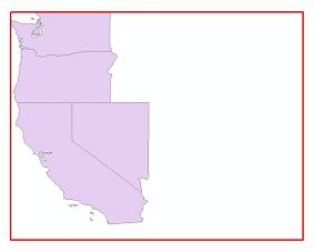
Consider the following scenario. A new feature class has features added to it. The IGeoDataset::Extent is then requested and an envelope is returned. The extents of the envelope returned are represented by the red box in the image below.

If a portion of the features were then deleted and the extent is again requested an envelope with the exact same extents as during the first request would be returned (see image below). This is because the deletion of features does not shrink the extent. However all additions of features outside the red box would increase the envelope returned to encompass the newly added features.

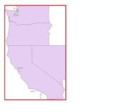
If you would like to update the IGeoDataset::Extent property to reflect the current features in your dataset please see IFeatureClassManage::UpdateExtent (also see IFeatureClassLoad). In the image below the extent has been updated and a new envelope is being returned.

ESRI's GroupLayer implements this property differently from most other layer coclasses. When you instantiate a new GroupLayer, this property will return a valid envelope with zero height and width. With most other newly instantiated layers (for example FeatureLayer, RasterLayer, TinLayer), this property initally returns Nothing.