
In this topic
Loading documents into ArcGIS Engine controls
Pre-authored documents can be loaded into the MapControl, PageLayoutControl, GlobeControl, and SceneControl using the following methods:
- At run time by the end user interactively using the ControlsOpenDocCommand, ControlsGlobeOpenDocCommand, and ControlsSceneOpenDocCommand that are typically added to a ToolbarControl, to browse and load map documents (*.mxd, *.mxt, *.pmf) into the MapControl and PageLayoutControl, globe documents (*.3dd) into the GlobeControl, and scene documents (*.sxd) into the SceneControl.
- Programmatically using the IMapControl2.LoadMxFile, IPageLayoutControl.LoadMxFile, IGlobeControl.Load3dFile, and ISceneControl.LoadSxFile methods.
- At design time through the controls property pages. For more information, see the following topics:
Loading data layers into ArcGIS Engine controls
Individual data layers can be loaded into the MapControl, PageLayoutControl, GlobeControl, and SceneControl using the following methods:
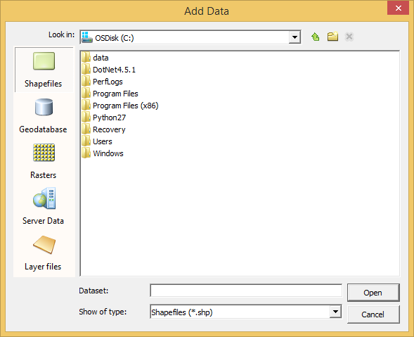
- At run time by the end user interactively using the ControlsAddDataCommand that is typically added to the ToolbarControl to browse and add shapefiles, geodatabase, rasters, server data and Layer files to the MapControl, PageLayoutControl, and GlobeControl. See the following screen shot of the Add Data dialog box:
At run time by the end user interactively dragging and dropping data layers from Windows Explorer and ArcCatalog onto the MapControl and PageLayoutControl, when object linking and embedding (OLE) drop functionality has been implemented. For more information, see How to drop data onto the MapControl.
- Programmatically using the IMapControl2.AddLayer, IMap.AddLayer, IMap.AddLayers, IScene.AddLayer, IScene.AddLayers, and IGlobe.AddLayerType methods.
- At design time through the MapControl property pages.
At 9.3, the All Types panel has been removed. If this functionality is still needed, create the following registry key:
- HKEY_CURRENT_USER\Software\ESRI\Controls\Commands\Generic\AddData\ShowAllTypesInDesktopApps.
If this key exists, the Engine Add Data dialog box shows the All Types panel in desktop applications.
| Development licensing | Deployment licensing |
|---|---|
| Engine Developer Kit | Engine |
| ArcGIS for Desktop Basic | |
| ArcGIS for Desktop Standard | |
| ArcGIS for Desktop Advanced |