获得 Production Mapping 许可后可用。
Product classes are types of geographic products designed for a particular use, typically unique groups of maps, charts, or digital data that share common properties. You can add product classes to each solution to be able to organize and find different types of products easily.
- 启动 ArcMap。
- If necessary, open the Product Library window by clicking Customize > Production > Product Library on the main menu.
A tree view of the product library appears.

- Expand Product Library and Products.
- Right-click the solution to which you want to add a product class and click New Class.
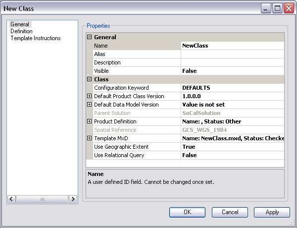
The New Class dialog box appears.

- Click the cell next to Name.
The name is limited to 16 characters. Special characters are not valid entries.
- Double-click the existing text and type a name for the product class in the text box.
- Click the cell next to Alias.
- Type the name you want displayed in the Product Library tree view for the product class.
- Click the cell next to Description.
- Type a description for the product class in the text box.
- Click the cell next to Visible.
- Click the drop-down arrow and choose an option to indicate whether the product class is going to be visible to other users in the Product Library tree view.
The default value is False.
- If necessary, click the cell next to Configuration Keyword, click the drop-down arrow, and choose a keyword from the database.
The configuration keyword is unique to the database and determines the way the tables are built.
- If necessary, change the default product class version.
- Set the default data model version.
- Set the product definition file.
- If you do not want to use the blank template MXD that is created by default, change the template MXD file.
- If necessary, click the cell next to Use Geographic Extent, click the drop-down arrow, then choose an option to indicate whether you are using geographic extents with your product class.
- Click the cell next to Use Relational Query.
- Click the drop-down arrow and choose an option to indicate whether relational queries are being used with the product class.
The default value is False.
- Click OK to close the dialog box.
The product class appears in the Product Library tree view.