Mit der Spatial Analyst-Lizenz verfügbar.
Zusammenfassung
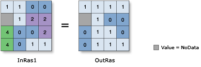
Returns 1 for cells where the first raster is less than the second raster and 0 if it is not.
Abbildung

Beschreibung
The relational less-than operation evaluates the first input value in relation to the second input value on a cell-by-cell basis within the Analysis window. In the relational evaluation, if the condition is true (the first input value is less than the second input value), the output is 1; if it is false, the output is 0.
    Input1 < Input2, Output = 1
    Input1 = Input2, Output = 0
    Input1 > Input2, Output = 0
When one or both input values are NoData, the output is NoData.
Bei Verwendung eines Operators mit einem Eingabe-Raster ist das Ergebnis ein Raster. Wenn jedoch alle Eingaben Zahlen sind, dann ist das Ergebnis ebenfalls eine Zahl.
Wenn in einem Ausdruck mehrere Operatoren verwendet werden, werden sie nicht zwingend von links nach rechts ausgeführt. Vielmehr wird der Operator mit dem höchsten Vorrangswert zuerst ausgeführt. Weitere Informationen zu Operatorrangfolge finden Sie unter Operatorrangfolgentabelle. Sie können die Reihenfolge der Ausführung jedoch mithilfe von Klammern steuern.
Boolesche Operatoren (~, &, ^, |) haben eine höhere Vorrangstufe als relationale Operatoren (<, <=, >, >=, ==, !=). Daher werden die booleschen Operatoren zuerst ausgeführt, wenn boolesche Operatoren im gleichen Ausdruck wie relationale Operatoren verwendet werden. Verwenden Sie Klammern, um die Reihenfolge der Ausführung zu ändern.
Wenn mehrere relationale und/oder boolesche Operatoren hintereinander in einem einzelnen Ausdruck verwendet werden, kann die Ausführung in Einzelfällen fehlschlagen. Um dieses potenzielle Problem zu vermeiden, verwenden Sie in dem Ausdruck geeignete Klammern, damit die Reihenfolge für die Ausführung der Operatoren explizit definiert ist. Weitere Informationen finden Sie unter Regeln für komplexe Anweisungen.
Zwei Eingaben sind notwendig, damit diese Auswertung stattfindet.
Für diesen Operator ist die Reihenfolge der Eingabe relevant.
Ausgabewerte sind immer ganzzahlig.
Syntax
in_raster_or_constant1 < in_raster_or_constant2
| Operand | Erläuterung | Datentyp |
in_raster_or_constant1 | The input being tested to determine if it is less than the second input. Wenn eine der Eingaben ein Raster und die andere ein Skalarwert ist, wird ein Ausgabe-Raster erstellt, wobei die Auswertung für jede Zelle im Eingabe-Raster durchgeführt wird. | Raster Layer | Constant |
in_raster_or_constant2 | The input against which the first input is tested to be less than. Wenn eine der Eingaben ein Raster und die andere ein Skalarwert ist, wird ein Ausgabe-Raster erstellt, wobei die Auswertung für jede Zelle im Eingabe-Raster durchgeführt wird. | Raster Layer | Constant |
Rückgabewert
| Name | Erläuterung | Datentyp |
| out_raster | Das Ausgabe-Raster-Objekt. Where cell values in the first input are less than that of the second input, the output cell value will be 1. If the values of the first input are equal to or greater than the second, the output value will be 0. | Raster |
Codebeispiel
< (Less Than) example 1 (Python window)
This sample performs a Less Than operation on two input rasters.
# Name: Op_LessThan_Ex_02.py
# Description: Performs a relational less-than operation on two inputs
#              on a cell-by-cell basis within the Analysis window
# Requirements: Spatial Analyst Extension

# Import system modules
import arcpy
from arcpy import env
from arcpy.sa import *

# Set environment settings
env.workspace = "C:/sapyexamples/data"

# Set local variables
inRaster1 = Raster("degs")
inRaster2 = Raster("negs")

# Check out the ArcGIS Spatial Analyst extension license
arcpy.CheckOutExtension("Spatial")

# Execute LessThan
outLessThan = inRaster1 < inRaster2

# Save the output
outLessThan.save("C:/sapyexamples/output/outlt")
< (Less Than) example 2 (stand-alone script)
This sample performs a Less Than operation on two input rasters.
# Name: Op_LessThan_Ex_02.py
# Description: Performs a relational less-than operation on two inputs
#              on a cell-by-cell basis within the Analysis window
# Requirements: Spatial Analyst Extension

# Import system modules
import arcpy
from arcpy import env
from arcpy.sa import *

# Set environment settings
env.workspace = "C:/sapyexamples/data"

# Set local variables
inRaster1 = Raster("degs")
inRaster2 = Raster("negs")

# Check out the ArcGIS Spatial Analyst extension license
arcpy.CheckOutExtension("Spatial")

# Execute LessThan
outLessThan = inRaster1 < inRaster2

# Save the output
outLessThan.save("C:/sapyexamples/output/outlt")