Mit der 3D Analyst-Lizenz verfügbar.
Zusammenfassung
Ermittelt für jede Zelle eines Rasters die Neigung (Gradient oder Steilheit).
Abbildung

Verwendung
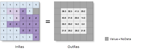
Zur Verarbeitung der Daten verwendet das Werkzeug ein bewegliches Fenster von 3 x 3 Zellen. Wenn der Typ der bearbeiteten Zelle "NoData" lautet, ist die Ausgabe für diese Position "NoData".
Of the eight cells neighboring the processing cell, this tool requires that at least seven of them have a valid value. Wenn weniger als sieben Zellen gültig sind, wird die Berechnung nicht ausgeführt, und die Ausgabe an dieser bearbeiteten Zelle lautet NoData.
The cells in the outermost rows and columns of the output raster will be NoData. Das liegt daran, dass die Zellen entlang der Grenze des Eingabe-Datasets nicht an ausreichend viele andere Zellen angrenzen.
Der Wertebereich in der Ausgabe hängt vom Typ der Maßeinheiten ab.
- Für Grad können Neigungswerte von 0 bis 90 angegeben werden.
- Für Prozentanstiege können Werte von 0 bis zu theoretisch unendlich angegeben werden. Eine flache Oberfläche entspricht 0 Prozent, eine Oberfläche mit 45 Grad entspricht 100 Prozent. Wenn die Oberfläche senkrechter wird, verstärkt sich der prozentuale Anstieg.
For the planar method, the use of a z-factor is essential for correct slope calculations when the surface (vertical) z-units are expressed in units different from the ground x,y units. The Z factor parameter will be enabled only when the planar method is selected.
For the geodesic method, specifying the surface z-unit is important to ensure the accuracy of the output. The Z unit parameter will be enabled only when the geodesic method is selected.
Wenn im vertikalen Koordinatensystem des Eingabe-Rasters eine Z-Einheit verfügbar ist, wird sie automatisch angewendet. It is suggested that you define a z-unit for the input raster if it is missing. You can use the Define Projection tool to specify a z-unit. If it is undefined, meter will be used by default.
Wenn das Eingabe-Raster neu berechnet werden muss, wird die bilineare Technik verwendet. Ein Eingabe-Raster muss beispielsweise dann neu berechnet werden, wenn das Ausgabe-Koordinatensystem, die Ausdehnung oder die Zellengröße sich von dem entsprechenden Wert der Eingabe unterscheidet.
This tool can be GPU accelerated when calculating geodesic slope, which means that if a GPU device (graphics processing unit) is available on your system, it will be used to enhance the performance of the geodesic method.
More information on how to configure your GPU device is available in the Spatial Analyst extension help in the GPU processing with Spatial Analyst help topic.
Syntax
Slope_3d (in_raster, out_raster, {output_measurement}, {z_factor}, {method}, {z_unit})| Parameter | Erläuterung | Datentyp |
in_raster | Das Eingabe-Oberflächen-Raster. | Raster Layer |
out_raster | Das Ausgabe-Neigungs-Raster. Es weist den Typ "Gleitkomma" auf. | Raster Dataset |
output_measurement (optional) | Hiermit werden die Maßeinheiten (Grad oder Prozent) der Ausgabeneigungs-Raster bestimmt.
| String |
z_factor (optional) | Number of ground x,y units in one surface z-unit. The z-factor adjusts the units of measure for the z-units when they are different from the x,y units of the input surface. Die Z-Werte der Eingabe-Oberfläche werden bei der Berechnung der endgültigen Ausgabe-Oberfläche mit dem Z-Faktor multipliziert. Falls die XY-Einheiten und die Z-Einheiten in denselben Maßeinheiten ausgedrückt sind, lautet der Z-Faktor 1. Dies ist die Standardeinstellung. If the x,y units and z-units are in different units of measure, the z-factor must be set to the appropriate factor, or the results will be incorrect. For example, if your z-units are feet and your x,y units are meters, you would use a z-factor of 0.3048 to convert your z-units from feet to meters (1 foot = 0.3048 meter). | Double |
method (optional) | Determines whether to calculate the aspect based on a planar (flat earth) or a geodesic (ellipsoid) method.
The planar method is appropriate to use on local areas in a projection that maintains correct distance and area. It is suitable for analysis that cover areas such cities, counties, or smaller states in area. The geodesic method produces a more accurate result, at the potential cost of an increase in processing time. | String |
z_unit (optional) | Linear unit of vertical z-values. It is defined by a vertical coordinate system if it exists. If a vertical coordinate system does not exist, the z-unit should be defined from the unit list to ensure correct geodesic computation. By default, Meter would be applied.
| String |
Codebeispiel
Slope – Beispiel 1 (Python-Fenster)
In diesem Beispiel werden die Neigungswerte im Eingabe-Oberflächen-Raster bestimmt.
import arcpy
from arcpy import env
env.workspace = "C:/data"
arcpy.Slope_3d("elevation", "C:/output/outslope01", "DEGREE", 0.3043)
Slope – Beispiel 2 (eigenständiges Skript)
In diesem Beispiel werden die Neigungswerte im Eingabe-Oberflächen-Raster bestimmt.
# Name: Slope_3d_Ex_02.py
# Description: Identifies the rate of maximum change
#              in z-value from each cell.
# Requirements: 3D Analyst Extension

# Import system modules
import arcpy
from arcpy import env

# Set environment settings
env.workspace = "C:/data"

# Set local variables
inRaster = "elevation"
outRaster = "C:/output/outslope02"
outMeasurement = "DEGREE"
zFactor = ""
method = "GEODESIC"
zUnit = "FOOT"

# Check out the ArcGIS 3D Analyst extension license
arcpy.CheckOutExtension("3D")

# Execute Slope
arcpy.Slope_3d(inRaster, outRaster, outMeasurement, zFactor, method, zUnit)
Umgebungen
Lizenzinformationen
- ArcGIS Desktop Basic: Erfordert 3D Analyst oder Spatial Analyst
- ArcGIS Desktop Standard: Erfordert 3D Analyst oder Spatial Analyst
- ArcGIS Desktop Advanced: Erfordert 3D Analyst oder Spatial Analyst