Zusammenfassung
A Polyline object is a shape defined by one or more paths, in which a path is a series of connected segments.
Auswertung
Bei vielen Workflows der Geoverarbeitung möchten Sie eventuell bestimmte Vorgänge mit Koordinaten- und Geometriedaten ausführen, jedoch nicht unbedingt eine neue (temporäre) Feature-Class erstellen, diese mit Cursorn füllen, die Feature-Class verwenden und dann die vorläufige Feature-Class wieder löschen. Sie können anstelle von Eingabe und Ausgabe auch Geometrieobjekte verwenden und so die Geoverarbeitung vereinfachen. Geometrieobjekte können von Grund auf neu mit Geometry-, Multipoint-, PointGeometry-, Polygon- oder Polyline-Classes erstellt werden.
Syntax
Polyline (inputs, {spatial_reference}, {has_z}, {has_m})| Parameter | Erklärung | Datentyp |
inputs | The coordinates used to create the object. The data type can be either Point or Array objects. | Object |
spatial_reference | The spatial reference of the new geometry. (Der Standardwert ist None) | SpatialReference |
has_z | The Z state: True for geometry if Z is enabled and False if it is not. (Der Standardwert ist False) | Boolean |
has_m | The M state: True for geometry if M is enabled and False if it is not. (Der Standardwert ist False) | Boolean |
Eigenschaften
| Eigenschaft | Erklärung | Datentyp |
| JSON (Nur lesen) | Returns an Esri JSON representation of the geometry as a string. | String |
| WKB (Nur lesen) | Returns the well-known binary (WKB) representation for OGC geometry. It provides a portable representation of a geometry value as a contiguous stream of bytes. | Bytearray |
| WKT (Nur lesen) | Returns the well-known text (WKT) representation for OGC geometry. It provides a portable representation of a geometry value as a text string. Any true curves in the geometry will be densified into approximate curves in the WKT string. | String |
| area (Nur lesen) | The area of a polygon feature. Empty for all other feature types. | Double |
| centroid (Nur lesen) | The true centroid if it is within or on the feature; otherwise, the label point is returned. Returns a point object. | Point |
| extent (Lesen und schreiben) | The extent of the geometry. | Extent |
| firstPoint (Nur lesen) | The first coordinate point of the geometry. | Point |
| hullRectangle (Nur lesen) | A space-delimited string of the coordinate pairs of the convex hull rectangle. | String |
| isMultipart (Nur lesen) | True, if the number of parts for this geometry is more than one. | Boolean |
| labelPoint (Nur lesen) | The point at which the label is located. The labelPoint is always located within or on a feature. | Point |
| lastPoint (Nur lesen) | The last coordinate of the feature. | Point |
| length (Nur lesen) | The length of the linear feature. Zero for point and multipoint feature types. | Double |
| length3D (Lesen und schreiben) | The 3D length of the linear feature. Zero for point and multipoint feature types. | Double |
| partCount (Nur lesen) | The number of geometry parts for the feature. | Integer |
| pointCount (Nur lesen) | The total number of points for the feature. | Integer |
| spatialReference (Nur lesen) | The spatial reference of the geometry. | SpatialReference |
| trueCentroid (Nur lesen) | The center of gravity for a feature. | Point |
| type (Nur lesen) | The geometry type: polygon, polyline, point, multipoint, multipatch, dimension, or annotation. | String |
Methodenübersicht
| Methode | Erklärung |
| angleAndDistanceTo (other, {method}) | Returns a tuple of angle and distance to another point using a measurement type. |
| boundary () | Constructs the boundary of the geometry. 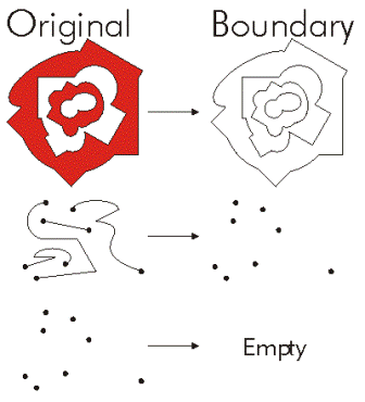 |
| buffer (distance) | Constructs a polygon at a specified distance from the geometry. 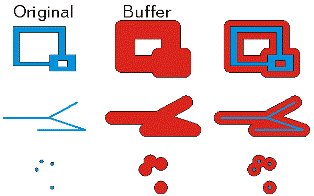 |
| clip (envelope) | Constructs the intersection of the geometry and the specified extent. 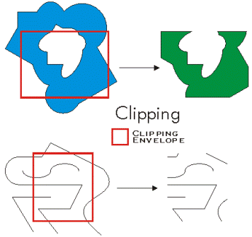 |
| contains (second_geometry, {relation}) | Indicates if the base geometry contains the comparison geometry. contains is the opposite of within. Only True relationships are shown in this illustration. 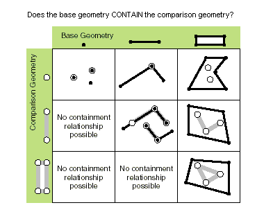 |
| convexHull () | Constructs the geometry that is the minimal bounding polygon such that all outer angles are convex. 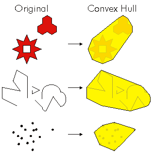 |
| crosses (second_geometry) | Gibt an, ob die beiden Geometrien sich in einer Geometrie mit einem geringeren Shape-Typ überschneiden. Zwei Polylinien kreuzen sich, wenn sie nur Punkte gemeinsam haben, von denen mindestens einer kein Endpunkt ist. Eine Polylinie und ein Polygon kreuzen sich, wenn sie im Inneren des Polygons eine Polylinie oder einen Punkt (für eine vertikale Linie) gemeinsam haben, die bzw. der nicht der gesamten Polylinie entspricht. Only True relationships are shown in this illustration. 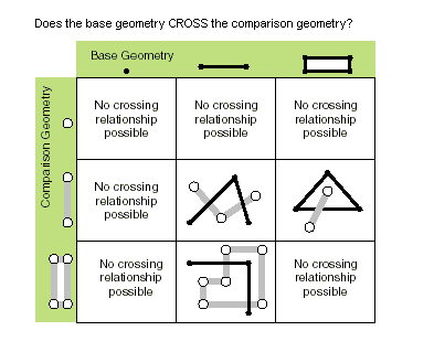 |
| cut (cutter) | Splits this geometry into a part left of the cutting polyline, and a part right of it. When a polyline or polygon is cut, it is split where it intersects the cutter polyline. Each piece is classified as left of or right of the cutter. This classification is based on the orientation of the cutter line. Parts of the target polyline that do not intersect the cutting polyline are returned as part of the right of result for that input polyline. If a geometry is not cut, the left geometry will be empty (None). 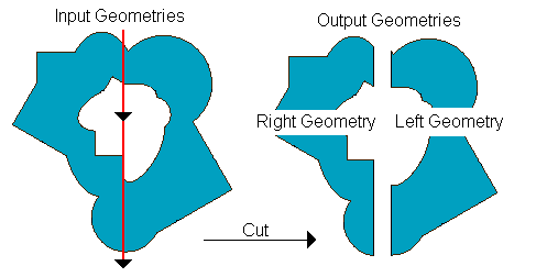 |
| densify (type, distance, deviation) | Creates a new geometry with added vertices. |
| difference (other) | Constructs the geometry that is composed only of the region unique to the base geometry but not part of the other geometry. The following illustration shows the results when the red polygon is the source geometry. 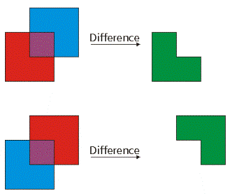 |
| disjoint (second_geometry) | Gibt an, ob die Basis- und die Vergleichsgeometrie keine gemeinsamen Punkte aufweisen. Zwei Geometrien überschneiden sich, wenn disjoint den Wert False zurückgibt. Only True relationships are shown in this illustration. 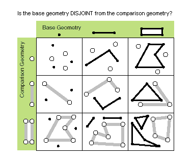 |
| distanceTo (other) | Returns the minimum distance between two geometries. If the geometries intersect, the minimum distance is 0. Both geometries must have the same projection. |
| equals (second_geometry) | Indicates if the base and comparison geometries are of the same shape type and define the same set of points in the plane. This is a 2D comparison only; M and Z values are ignored. Only True relationships are shown in this illustration. 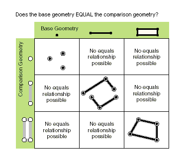 |
| generalize (max_offset) | Creates a new simplified geometry using a specified maximum offset tolerance. |
| getArea ({type}, {units}) | Returns the area of the feature using a measurement type. |
| getLength ({measurement_type}, {units}) | Returns the length of the feature using a measurement type. |
| getPart ({index}) | Returns an array of point objects for a particular part of geometry or an array containing a number of arrays, one for each part. |
| intersect (other, dimension) | Constructs a geometry that is the geometric intersection of the two input geometries. Different dimension values can be used to create different shape types. The intersection of two geometries of the same shape type is a geometry containing only the regions of overlap between the original geometries. 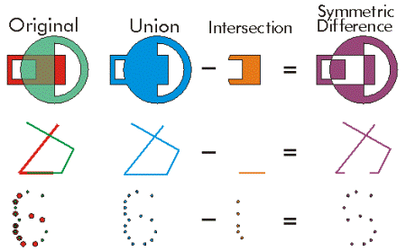 For faster results, test if the two geometries are disjoint before calling intersect. |
| measureOnLine (in_point, {use_percentage}) | Returns a measure from the start point of this line to the in_point. |
| overlaps (second_geometry) | Gibt an, üb die Überschneidung der beiden Geometrien denselben Shape-Typ wie eine der Eingabegeometrien aufweist, aber keiner der Eingabegeometrien entspricht. Only True relationships are shown in this illustration. 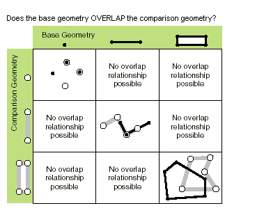 |
| pointFromAngleAndDistance (angle, distance, {method}) | Returns a point at a given angle in degrees and distance in the units of the geometry's spatial reference using the specified measurement type. |
| positionAlongLine (value, {use_percentage}) | Returns a point on a line at a specified distance from the beginning of the line. |
| projectAs (spatial_reference, {transformation_name}) | Projects a geometry and optionally applies a geotransformation. To project, the geometry needs to have a spatial reference, and not have an UnknownCoordinateSystem. The new spatial reference system passed to the method defines the output coordinate system. If either spatial reference is unknown the coordinates will not be changed. The Z- and measure values are not changed by the ProjectAs method. |
| queryPointAndDistance (in_point, {as_percentage}) | Finds the point on the polyline nearest to the in_point and the distance between those points. Also returns information about the side of the line the in_point is on as well as the distance along the line where the nearest point occurs. |
| segmentAlongLine (start_measure, end_measure, {use_percentage}) | Returns a Polyline between start and end measures. Similar to Polyline.positionAlongLine but will return a polyline segment between two points on the polyline instead of a single point. |
| snapToLine (in_point) | Returns a new point based on in_point snapped to this geometry. |
| symmetricDifference (other) | Constructs the geometry that is the union of two geometries minus the instersection of those geometries. The two input geometries must be the same shape type.  |
| touches (second_geometry) | Indicates if the boundaries of the geometries intersect. Two geometries touch when the intersection of the geometries is not empty, but the intersection of their interiors is empty. For example, a point touches a polyline only if the point is coincident with one of the polyline end points. Only True relationships are shown in this illustration. 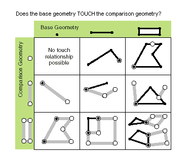 |
| union (other) | Constructs the geometry that is the set-theoretic union of the input geometries. The two geometries being unioned must be the same shape type.  |
| within (second_geometry, {relation}) | Indicates if the base geometry is within the comparison geometry. within is the opposite operator of contains. Only True relationships are shown in this illustration. 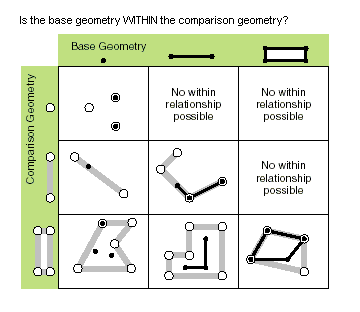 The base geometry is within the comparison geometry if the base geometry is the intersection of the geometries and the intersection of their interiors is not empty. within is a Clementini operator, except in the case of an empty base geometry. |
Methoden
angleAndDistanceTo (other, {method})| Parameter | Erklärung | Datentyp |
other | The second geometry. | PointGeometry |
method | PLANAR measurements reflect the projection of geographic data onto the 2D surface (in other words, they will not take into account the curvature of the earth). GEODESIC, GREAT_ELLIPTIC, LOXODROME, and PRESERVE_SHAPE measurement types may be chosen as an alternative, if desired.
(Der Standardwert ist GEODESIC) | String |
Rückgabewert
| Datentyp | Erklärung |
| tuple | Returns a tuple of angle (in degrees) and distance (in meters) to another point. |
boundary ()
Rückgabewert
| Datentyp | Erklärung |
| Object | A polygon's boundary is a polyline. A polyline's boundary is a multipoint, corresponding to the endpoints of the line. A point or multipoint's boundary is an empty point or multipoint. |
buffer (distance)
| Parameter | Erklärung | Datentyp |
distance | The buffer distance. The buffer distance is in the same units as the geometry that is being buffered. A negative distance can only be specified against a polygon geometry. | Double |
Rückgabewert
| Datentyp | Erklärung |
| Polygon | The buffered polygon geometry. |
clip (envelope)
| Parameter | Erklärung | Datentyp |
envelope | An extent object used to define the clip extent. | Extent |
Rückgabewert
| Datentyp | Erklärung |
| Object | An output geometry clipped to the specified extent. |
contains (second_geometry, {relation})| Parameter | Erklärung | Datentyp |
second_geometry | A second geometry. | Object |
relation | The spatial relationship type.
(Der Standardwert ist None) | String |
Rückgabewert
| Datentyp | Erklärung |
| Boolean |
A return Boolean value of True indicates this geometry contains the second geometry. |
convexHull ()
Rückgabewert
| Datentyp | Erklärung |
| Object | The resulting geometry. The convex hull of a single point is the point itself. |
crosses (second_geometry)
| Parameter | Erklärung | Datentyp |
second_geometry | A second geometry. | Object |
Rückgabewert
| Datentyp | Erklärung |
| Boolean | Der boolesche Rückgabetyp "True" gibt an, dass sich die beiden Geometrien in einer Geometrie mit einem geringeren Shape-Typ schneiden. |
cut (cutter)
| Parameter | Erklärung | Datentyp |
cutter | The cutting polyline geometry. | PolyLine |
Rückgabewert
| Datentyp | Erklärung |
| Geometry | A list of two geometries. |
densify (type, distance, deviation)
| Parameter | Erklärung | Datentyp |
type | The type of densification, DISTANCE, ANGLE, or GEODESIC.
| String |
distance | The maximum distance between vertices. The actual distance between vertices will usually be less than the maximum distance as new vertices will be evenly distributed along the original segment. If using a type of DISTANCE or ANGLE, the distance is measured in the units of the geometry's spatial reference. If using a type of GEODESIC, the distance is measured in meters. | Double |
deviation | Densify uses straight lines to approximate curves. You use deviation to control the accuracy of this approximation. The deviation is the maximum distance between the new segment and the original curve. The smaller its value, the more segments will be required to approximate the curve. If using a type of DISTANCE, the deviation is measured in the units of the geometry's spatial reference. If using a type of ANGLE, the deviation is measured in radians. If using a type of GEODESIC, the deviation is not used. | Double |
Rückgabewert
| Datentyp | Erklärung |
| Geometry | The densified geometry. |
difference (other)
| Parameter | Erklärung | Datentyp |
other | A second geometry. | Object |
Rückgabewert
| Datentyp | Erklärung |
| Object | The resulting geometry. |
disjoint (second_geometry)
| Parameter | Erklärung | Datentyp |
second_geometry | A second geometry. | Object |
Rückgabewert
| Datentyp | Erklärung |
| Boolean | Der boolesche Rückgabetyp "True" gibt an, dass die beiden Geometrien keine gemeinsamen Punkte aufweisen. |
distanceTo (other)
| Parameter | Erklärung | Datentyp |
other | A second geometry. | Object |
Rückgabewert
| Datentyp | Erklärung |
| Double | The distance between the two geometries. |
equals (second_geometry)
| Parameter | Erklärung | Datentyp |
second_geometry | A second geometry. | Object |
Rückgabewert
| Datentyp | Erklärung |
| Boolean |
A return Boolean value of True indicates that the two geometries are of the same shape type and define the same set of points in the plane. |
generalize (max_offset)
| Parameter | Erklärung | Datentyp |
max_offset | The maximum offset tolerance. | Double |
Rückgabewert
| Datentyp | Erklärung |
| Geometry | The generalized geometry. |
getArea ({type}, {units})| Parameter | Erklärung | Datentyp |
type | PLANAR measurements reflect the projection of geographic data onto the 2D surface (in other words, they will not take into account the curvature of the earth). GEODESIC, GREAT_ELLIPTIC, LOXODROME, and PRESERVE_SHAPE measurement types may be chosen as an alternative, if desired.
(Der Standardwert ist GEODESIC) | String |
units | The units in which the area will be calculated.
| String |
Rückgabewert
| Datentyp | Erklärung |
| Double | The area of the feature. By default, for Projected coordinate systems, area will be returned in the units of the coordinate system, and for Geographic coordinate systems, area will be returned in square meters. |
getLength ({measurement_type}, {units})| Parameter | Erklärung | Datentyp |
measurement_type | PLANAR measurements reflect the projection of geographic data onto the 2D surface (in other words, they will not take into account the curvature of the earth). GEODESIC, GREAT_ELLIPTIC, LOXODROME, and PRESERVE_SHAPE measurement types may be chosen as an alternative, if desired.
(Der Standardwert ist GEODESIC) | String |
units | The units in which the length will be calculated.
| String |
Rückgabewert
| Datentyp | Erklärung |
| Double | The length of the feature. By default, for Projected coordinate systems, length will be returned in the units of the coordinate system, and for Geographic coordinate systems, length will be returned in square meters. |
getPart ({index})| Parameter | Erklärung | Datentyp |
index | The index position of the geometry. | Integer |
Rückgabewert
| Datentyp | Erklärung |
| Array | getPart returns an array of point objects for a particular part of the geometry if an index is specified. If an index is not specified, an array containing an array of point objects for each geometry part is returned. |
intersect (other, dimension)
| Parameter | Erklärung | Datentyp |
other | The second geometry. | Object |
dimension | The topological dimension (shape type) of the resulting geometry.
| Integer |
Rückgabewert
| Datentyp | Erklärung |
| Object | A new geometry (point, multipoint, polyline, or polygon) that is the geometric intersection of the two input geometries. |
measureOnLine (in_point, {use_percentage})| Parameter | Erklärung | Datentyp |
in_point | A point (PointGeometry or Point) that is used to measure from the start point of the polyline. | PointGeometry |
use_percentage | If False, the measure will be returned as a distance; if True, the measure will be returned as a percentage. (Der Standardwert ist False) | Boolean |
Rückgabewert
| Datentyp | Erklärung |
| Double | A distance or percentage. |
overlaps (second_geometry)
| Parameter | Erklärung | Datentyp |
second_geometry | A second geometry. | Object |
Rückgabewert
| Datentyp | Erklärung |
| Boolean | Der boolesche Rückgabetyp True gibt an, dass die Überschneidung der beiden Geometrien dieselbe Dimension wie eine der Eingabegeometrien aufweist. |
pointFromAngleAndDistance (angle, distance, {method})| Parameter | Erklärung | Datentyp |
angle | The angle in degrees to the returned point. | Double |
distance | The distance in the units of the geometry's spatial reference to the returned point. | Double |
method | PLANAR measurements reflect the projection of geographic data onto the 2D surface (in other words, they will not take into account the curvature of the earth). GEODESIC, GREAT_ELLIPTIC, LOXODROME, or PRESERVE_SHAPE measurement types can be chosen as an alternative if desired.
(Der Standardwert ist GEODESIC) | String |
Rückgabewert
| Datentyp | Erklärung |
| PointGeometry | Returns a point at a given angle and distance in degrees and meters. |
positionAlongLine (value, {use_percentage})| Parameter | Erklärung | Datentyp |
value | The distance along the line. If the distance is less than zero, then the starting point of the line will be returned; if the distance is greater than the length of the line, then the end point of the line will be returned. | Double |
use_percentage | The distance may be specified as a fixed unit of measure or a ratio of the length of the line. If True, value is used as a percentage; if False, value is used as a distance. For percentages, the value should be expressed as a double from 0.0 (0%) to 1.0 (100%). (Der Standardwert ist False) | Boolean |
Rückgabewert
| Datentyp | Erklärung |
| PointGeometry | The point on the line at a specified distance from the beginning of the line. |
projectAs (spatial_reference, {transformation_name})| Parameter | Erklärung | Datentyp |
spatial_reference | The new spatial reference. This can be a SpatialReference object or the coordinate system name. | SpatialReference |
transformation_name | The geotransformation name. | String |
Rückgabewert
| Datentyp | Erklärung |
| Object | The projected geometry. |
queryPointAndDistance (in_point, {as_percentage})| Parameter | Erklärung | Datentyp |
in_point | The input point (PointGeometry or Point). | PointGeometry |
as_percentage | If False, the measure will be returned as a distance; if True, the measure will be returned as a percentage. (Der Standardwert ist False) | Boolean |
Rückgabewert
| Datentyp | Erklärung |
| tuple | Returns a tuple that includes the following:
|
segmentAlongLine (start_measure, end_measure, {use_percentage})| Parameter | Erklärung | Datentyp |
start_measure | The starting distance from the beginning of the line. | Double |
end_measure | The ending distance from the beginning of the line. | Double |
use_percentage | The start and end measures may be specified as fixed units or as a ratio. If True, start_measure and end_measure are used as a percentage; if False, start_measure and end_measure are used as a distance. For percentages, the measures should be expressed as a double from 0.0 (0 percent) to 1.0 (100 percent). (Der Standardwert ist False) | Boolean |
Rückgabewert
| Datentyp | Erklärung |
| PolyLine | The segment of the line between two points. |
snapToLine (in_point)
| Parameter | Erklärung | Datentyp |
in_point | A point (PointGeometry or Point) to be snapped to the line. | PointGeometry |
Rückgabewert
| Datentyp | Erklärung |
| PointGeometry | The snapped point. |
symmetricDifference (other)
| Parameter | Erklärung | Datentyp |
other | A second geometry. | Object |
Rückgabewert
| Datentyp | Erklärung |
| Object | The resulting geometry. |
touches (second_geometry)
| Parameter | Erklärung | Datentyp |
second_geometry | A second geometry. | Object |
Rückgabewert
| Datentyp | Erklärung |
| Boolean | A return Boolean value of True indicates the boundaries of the geometries intersect. |
union (other)
| Parameter | Erklärung | Datentyp |
other | A second geometry. | Object |
Rückgabewert
| Datentyp | Erklärung |
| Object | The resulting geometry. |
within (second_geometry, {relation})| Parameter | Erklärung | Datentyp |
second_geometry | A second geometry. | Object |
relation | The spatial relationship type.
(Der Standardwert ist None) | String |
Rückgabewert
| Datentyp | Erklärung |
| Boolean | A return Boolean value of True indicates this geometry is contained within the second geometry. |
Codebeispiel
Polyline example
Create a polyline feature class from scratch.
import arcpy

# A list of features and coordinate pairs
feature_info = [[[1, 2], [2, 4], [3, 7]],
                [[6, 8], [5, 7], [7, 2], [9, 5]]]

# A list that will hold each of the Polyline objects
features = []

for feature in feature_info:
    # Create a Polyline object based on the array of points
    # Append to the list of Polyline objects
    features.append(
        arcpy.Polyline(
            arcpy.Array([arcpy.Point(*coords) for coords in feature])))

# Persist a copy of the Polyline objects using CopyFeatures
arcpy.CopyFeatures_management(features, "c:/geometry/polylines.shp")