You can rotate features using the Rotate tool  . With this tool active, drag the pointer to rotate the selected features to the desired orientation. You can also specify an exact rotation angle by pressing the A key while rotating.
There are many cases where your data is not oriented properly and needs to be rotated. One might be that you need to duplicate some features and position them at an angle different from the original features. Another case could be that you have received some data that just needs to be rotated to fit in with the rest of your data.
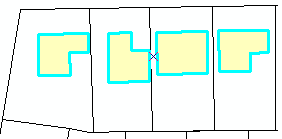
For example, you have imported some CAD building footprint data into your geodatabase. However, the buildings are oriented vertically when they need to be horizontal.

You can use the Rotate tool and rotate the features either interactively or at a specific angle so they fit properly into your parcel data.

The Rotate tool uses the selection anchor (the small x located in the center of the selected features) as a pivot point for the rotation. You can drag the selection anchor to a new location to change the center of rotation. You can use snapping to accurately place it.
While rotating features you can use the auxiliary anchor to snap the features. Press the S key to turn on/off the auxiliary anchor. Move the pointer over it, then drag the auxiliary anchor to the desired location. The selection anchor and auxiliary anchor both use the current snapping environment when you are dragging them. The auxiliary anchor snaps to features while you are rotating.
Rotating annotation: You can rotate annotation features using the Rotate tool. In addition, annotation features selected with the Edit Annotation tool have special handles that allow you to rotate them by clicking and dragging or by using rotate mode.
- Click the Edit tool
 on the Editor toolbar.
- Click the feature or features that you want to rotate. Hold down the SHIFT key while clicking features to select additional features.
- Click the Rotate tool
 on the Editor toolbar.
- Click anywhere on the map and drag the pointer to rotate the feature to the desired orientation. To specify the exact degree of rotation, press the A key, and type the number of degrees. The angle is applied relative to the current orientation. A positive number rotates the feature to the right; a negative number rotates it to the left. Angular units are determined by the angular or direction units setting on the Units tab of the Editing Options dialog box.