Available with Standard or Advanced license.
The Check Parcel Fabric command is available for validating the topological integrity of your parcel fabric. The command identifies data corruptions such as out-of-sequence parcel traverse lines, parcels that are not closed, invalid dimensions and so on. To run the command, right-click a parcel fabric dataset in the Catalog window and click Check Parcel Fabric.
Checking the fabric is useful for validating parcel data that has been migrated to the fabric. When migrating data into the fabric, inconsistencies and errors in the source data can result in corruptions in the fabric. The command identifies data corruptions in the fabric and reports the errors in a list format that can be saved for future use. All reported check fabric errors do not need to be fixed immediately. Check fabric errors can be fixed over time, as needed in the area in which you are working. If you are adjusting a selection of parcels using the least-squares adjustment, it is best to have all check fabric errors fixed in those selected parcels to ensure a successful adjustment.
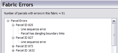
Check parcel fabric errors are reported on the Fabric Errors dialog box. Errors found in parcels, lines, and points are listed with the ObjectID of the corrupt feature. The ObjectID can then be used to locate the corresponding feature in the parcel fabric. The corrupt feature can be either edited and corrected or unjoined and deleted.
The following errors are reported:
Parcel errors
In most cases, the following parcel errors are most easily corrected by deleting or unjoining the corrupt parcel and re-entering a new, correct parcel. In some cases, regenerating the parcel can fix the error.
Parcel does not have a valid shape
The parcel does not have a valid, geometric shape; for example, the parcel shape is self-intersecting or the parcel has no geometric shape (the shape is null).
Line sequence error
The parcel contains lines that are out of sequence.
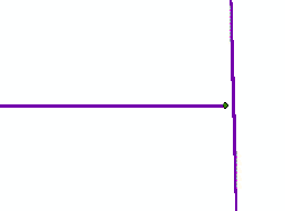
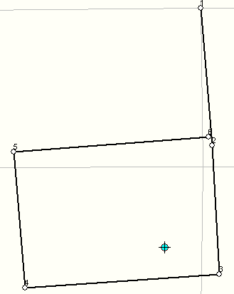
In this case, the parcel's traverse lines are out of sequence, for example, 1-2-4-3. Line sequence errors are caused either by incorrect data entry of the parcel traverse or by dangling, overshot/undershot, or tiny line segments in migrated data. For example, in the parcel line feature class shown below, an undershot line is resulting in a failure by the importer to create a fabric parcel:
Often, the corrupt parcel is not rendered in the fabric. To open and examine the parcel, the parcel must be selected in the parcel layer's attribute table and opened by right-clicking the parcel, which is listed in the Parcel Explorer dialog box. In some cases, regenerating the parcel may fix this error.
Line sequences do not start at 1
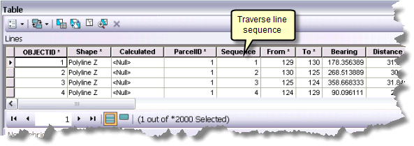
The sequence IDs of the lines within this parcel do not start at 1. Parcel traverse lines are stored in the Lines table, and the sequence of the traverse lines should always start at 1.
Causes
- Road centerline parcels with multiple paths
Each path should be a separate parcel and not form one single parcel.
- Connection line as the first line of the parcel
The line category should be changed to Origin Connection rather than Connection.
- Incorrect from- and to-point IDs in the traverse grid
Sometimes this is caused by incorrect data entry when entering a parcel in a parcel group.
Often, the corrupt parcel is not rendered in the fabric. To open and examine the parcel, the parcel must be selected in the parcel layer's attribute table and opened by right-clicking the parcel, which is listed in the Parcel Explorer dialog box.
Parcel has dangling boundary links
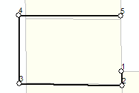
This error can result from a parcel traverse that does not close back onto its starting point.
Causes
- Dangling or overshot lines in migrated data, which has resulted in incorrectly assigned from- and to-points
- Overlapping lines in migrated data, which has resulted in a duplicate parcel line in the parcel fabric
Parcel has disconnected links
A disconnected link is a line that is not connected to or part of a parcel boundary but is stored as a parcel traverse line for that parcel boundary. This line could be connected to another parcel boundary in the fabric but is related to the wrong parcel.
Possible causes
- Incorrect data entry or migration of poor-quality parcel data
- Data corruption resulting from manually editing parcel fabric system tables
Parcel has missing points
This parcel's boundary lines are referencing point IDs that do not exist.
Possible causes
- Data corruption resulting from manually editing parcel fabric system tables
- Migration of poor-quality parcel data
Regenerate the parcel to fix this error.
Parcel contains lines with errors
There are errors on some of the traverse lines of this parcel. A list of line errors should appear with the parcel error. Examples of line errors are invalid line categories and invalid line radii. See the 'Line errors' section for a more detailed explanation of each type of line error.
Parcel contains line points with errors
There are errors on some of this parcel's points that are line points on other parcels. A list of line point errors should appear with the parcel error. Examples of line point errors are invalid referenced point IDs—for example, the line point refers to a point on the parcel that does not exist—and invalid referenced lines. See the 'Line point errors' section for a more detailed explanation of each type of line point error.
Parcel contains points with errors
There are errors on some of this parcel's points. A list of point errors should appear with this parcel error. Examples of point errors are invalid coordinates and invalid curve center points. See the 'Point errors' section for a more detailed explanation of each type of line point error.
Parcel does not have valid shape
The parcel does not have a valid, geometric shape; for example, the parcel shape is self-intersecting or the parcel has no geometric shape (the shape is null).
Line errors
Line has invalid ID
The ObjectID of this line is not valid.
Unjoin the parcel that contains the line and open the unjoined parcel. Delete and re-enter the corrupt line. Join the parcel back to the parcel fabric layer.
Line has invalid sequence
The sequence value for this line (in the Sequence attribute field in the parcel lines table) is not a valid number.
Unjoin the parcel that contains the line and open the unjoined parcel. Check that the line sequencing (From and To points) of the parcel traverse is correct. If necessary, delete and re-enter the corrupt lines. Join the parcel back to the parcel fabric layer.
Line has invalid category
The category value for this line ( in the Category attribute field) is not a recognized value. The following line categories are recognized:
- 0—Boundary line
- 1—Dependent line
- 2—Precise connection line
- 3—Connection line
- 4—Radial line
- 5—Road frontage line
- 6—Origin connection line
- 7—Part connection line
Open the parcel and choose a valid category under the Category field on the Lines tab.
Line has invalid from point
The parcel line is referencing an invalid from-point ID. The referenced point ID most likely does not exist in the points table.
Regenerate the parcel to fix this error.
Line has invalid to point
The parcel line is referencing an invalid to-point ID. The referenced point ID most likely does not exist in the points table.
Regenerate the parcel to fix this error.
Line has invalid center point
The center point for this curved line is invalid. The referenced point ID most likely does not exist in the points table.
Regenerate the parcel to fix this error.
Line has invalid radius
The value stored in the Radius attribute field for the curved line is invalid. The radius value is most likely missing.
Regenerate the parcel to fix this error.
Line does not have a valid shape
The line shape geometry is invalid. The line shape could be corrupt or missing.
Unjoin the parcel that contains the line and open the unjoined parcel. Delete and re-enter the corrupt line. Join the parcel back to the parcel fabric layer. In some cases it may be easiest to delete the parcel and re-enter a new parcel.
Line has same from and to points
This line is referencing the same from- and to-point IDs. The same from- and to-point IDs can be seen in both the parcel traverse dialog box and in the FromPointID and ToPointID attribute fields in the Lines table.
Causes
- Incorrect data entry of the parcel traverse
- Overlapping lines of different lengths in data that has been migrated to the parcel fabric
Unjoin the parcel that contains the line and open the unjoined parcel. Delete and re-enter the corrupt line. Join the parcel back to the parcel fabric layer. In some cases it may be easiest to delete the parcel and re-enter a new parcel.
Prevent or minimise this error by running a topology to find overlapping lines in your data before migration into the parcel fabric.
Curve is missing a radial line
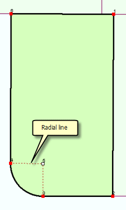
Each curved line in a fabric parcel has two stored radial lines in the lines table. This error is generated when a curve has one or both radial lines missing.
Causes
- Incorrectly stored and entered multiring or donut parcels
- Poor-quality data that has been migrated to the parcel fabric
Regenerate the parcel to fix this error.
Other lines in this parcel boundary have the same from PointID or Other lines in this parcel boundary have the same to PointID
Causes:
- The to and from points of the line have been reversed. This could occur when a traverse line is out of sequence.
- A point in the parcel connects more than two boundary lines. This could occur when a connection line has been incorrectly categorized as a boundary line.
Unjoin and open the parcel. Delete and re-enter corrupt lines. Join the parcel back to the parcel fabric layer. In some cases it may be easiest to delete the parcel and re-enter a new parcel.
Point errors
Invalid coordinate
One or all of the x,y,z coordinate values of the parcel point are invalid. A coordinate might be missing or might contain an invalid number or character.
Regenerate the parcel to fix this error.
The center point attribute is set incorrectly
If a point is the center point of a curve, it is flagged with a value of 1 in the CenterPoint attribute field in the Points table. This error occurs when a point is not the center point of a curve and has a CenterPoint attribute value of 1.
Regenerate the parcel to fix this error.
Point is missing
A point is being referenced that most likely does not exist in the Points table. For example, this error will occur if a line references a from- or to-point that does not exist in the Points table.
Regenerate the parcel to fix this error.
Point does not have a valid shape
The point shape geometry is invalid. The point shape could be corrupt or missing.
Regenerate the parcel to fix this error.
Line point errors
Linepoint does not refer to a valid point
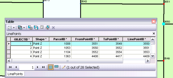
A parcel point becomes a line point when it lies on an adjacent parcel boundary but does not split the boundary. In the LinePoints table, LinePointID references a point ID in the Points table. This error will occur when the LinePointID attribute value is not a valid point ID. The point ID most likely is missing.
Regenerate the parcel to fix this error.
Linepoint does not have a valid from point
The point ID referenced in the FromPointID field is not a valid point ID. The point ID is most likely missing.
Regenerate the parcel to fix this error.
Linepoint does not have a valid to point
The point ID referenced in the ToPointID field is not a valid point ID. The point ID is most likely missing.
Regenerate the parcel to fix this error.
Linepoint does not have a valid line
This error occurs when a line does not exist between the from- and to-point IDs (FromPointID, ToPointID) referenced in the LinePoints table.
Use the Delete Line Point tool  on the Parcel Editor toolbar to delete the line point. Add a new line point using the Add Line Point tool
  .
.
Control point errors
Control point has invalid coordinates
One or all of the x,y,z coordinate values of the control point are invalid. A coordinate might be missing or might contain an invalid number or character.
Select the control point and regenerate the geometry to fix this error.
Control point back reference is invalid
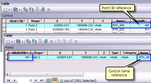
A control point references the fabric point to which it is associated via the PointID field in the Control table. The fabric point stores a back reference to the control point via the Name field in the Points table. This error indicates that the ID referenced in the Points or Control table are either incorrect or missing.
Use the Match Control Point tool on the Parcel Editor toolbar to re-link the control point to the correct parcel fabric point.