Summary
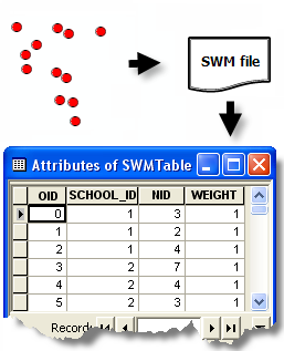
Converts a binary spatial weights matrix file (.swm) to a table.
Illustration

Usage
This tool allows you to edit a spatial weights matrix file, if necessary:
- Create a spatial weights matrix file using the Generate Spatial Weights Matrix or Generate Network Spatial Weight tool.
- Convert the resultant spatial weights matrix file to a table using this tool.
- Edit the table and modify the spatial relationships as desired.
- Use the Generate Spatial Weights Matrix tool to convert the modified table back to the binary spatial weights matrix file format.
Syntax
ConvertSpatialWeightsMatrixtoTable_stats (Input_Spatial_Weights_Matrix_File, Output_Table)
| Parameter | Explanation | Data Type |
Input_Spatial_Weights_Matrix_File | The full pathname for the spatial weights matrix file (.swm) you want to convert. | File |
Output_Table | A full pathname to the table you want to create. | Table |
Code sample
Convert Spatial Weights Matrix to Table Example (Python Window)
The following Python Window script demonstrates how to use the Convert Spatial Weights Matrix to Table tool.
import arcpy
arcpy.env.workspace = "c:/data"
arcpy.ConvertSpatialWeightsMatrixtoTable_stats("euclidean6Neighs.swm","euclidean6Neighs.dbf")
Convert Spatial Weights Matrix to Table Example (Stand-alone Python script)
The following stand-alone Python script demonstrates how to use the Convert Spatial Weights Matrix to Table tool.
# Create a Spatial Weights Matrix based on Network Data

# Import system modules
import arcpy

# Set property to overwrite existing output
arcpy.arcpy.overwriteOutput = True

# Local variables...
workspace = r"C:\Data\USCounties\US"

try:
    # Set the current workspace (to avoid having to specify the full path to the feature classes each time)
    arcpy.env.workspace = workspace

    # Create Spatial Weights Matrix
    # Process: Generate Spatial Weights Matrix...
    swm = arcpy.GenerateSpatialWeightsMatrix_stats("USCounties.shp", "MYID",
                        "euclidean6Neighs.swm",
                        "K_NEAREST_NEIGHBORS",
                        "#", "#", "#", 6)

    # Dump Spatial Weights to Database Table
    # Process: Convert Spatial Weights Matrix to Table...
    dbf = arcpy.ConvertSpatialWeightsMatrixtoTable_stats("euclidean6Neighs.swm",
                        "euclidean6Neighs.dbf")

    # Now you can edit the spatial weights (add, subtract and alter
    # neighbors and weights)

    # Read weights from table back into Spatial Weights Matrix format
    # Process: Generate Spatial Weights Matrix...
    swm = arcpy.GenerateSpatialWeightsMatrix_stats("USCounties.shp", "MYID",
                        "euclidean6Neighs.swm",
                        "CONVERT_TABLE",
                        "#", "#", "#",
                        "#", "#", "#",
                        "euclidean6Neighs.dbf")

except arcpy.ExecuteError:
    # If an error occurred when running the tool, print out the error message.
    print(arcpy.GetMessages())
Environments
Licensing information
- ArcGIS Desktop Basic: Yes
- ArcGIS Desktop Standard: Yes
- ArcGIS Desktop Advanced: Yes