ArcGIS Desktop

  • ArcGIS Pro
  • ArcMap

  • My Profile
  • Help
  • Sign Out
ArcGIS Desktop

ArcGIS Online

The mapping platform for your organization

ArcGIS Desktop

A complete professional GIS

ArcGIS Enterprise

GIS in your enterprise

ArcGIS for Developers

Tools to build location-aware apps

ArcGIS Solutions

Free template maps and apps for your industry

ArcGIS Marketplace

Get apps and data for your organization

  • Documentation
  • Support
Esri
  • Sign In
user
  • My Profile
  • Sign Out

ArcMap

  • Home
  • Get Started
  • Map
  • Analyze
  • Manage Data
  • Tools
  • Extensions

Changing the orientation of a raster

Sometimes your raster data may not be in the proper orientation. When this is the case, the Flip and Rotate tools can help you orient your data in the manner you want it to be displayed. The Rotate tool will turn (or rotate) your raster dataset; the pivot point of the raster is the lower left corner of the image, unless otherwise specified. The Flip tool will flip the raster dataset either vertically or horizontally.

The illustration below shows how the Rotate tool works; it depicts a raster dataset being rotated approximately 45 degrees (clockwise).

Rotating a raster

The images below show examples of raster datasets being flipped. The first example shows a raster dataset that is flipped horizontally. The second image shows a raster dataset being flipped vertically. A vertical flip is not the same as a 180-degree rotation.
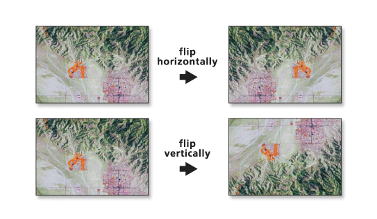
Images of raster datasets flipped horizontally and vertically

Related topics

  • Fundamentals of georeferencing a raster dataset

ArcGIS Desktop

  • Home
  • Documentation
  • Support

ArcGIS Platform

  • ArcGIS Online
  • ArcGIS Desktop
  • ArcGIS Enterprise
  • ArcGIS for Developers
  • ArcGIS Solutions
  • ArcGIS Marketplace

About Esri

  • About Us
  • Careers
  • Esri Blog
  • User Conference
  • Developer Summit
Esri
Tell us what you think.
Copyright © 2020 Esri. | Privacy | Legal