ArcGIS Desktop

  • ArcGIS Pro
  • ArcMap

  • My Profile
  • ヘルプ
  • Sign Out
ArcGIS Desktop

ArcGIS Online

組織のマッピング プラットフォーム

ArcGIS Desktop

完全なプロ仕様の GIS

ArcGIS Enterprise

エンタープライズ GIS

ArcGIS for Developers

位置情報利用アプリの開発ツール

ArcGIS Solutions

各種業界向けの無料のテンプレート マップおよびテンプレート アプリケーション

ArcGIS Marketplace

組織で使えるアプリとデータを取得

  • ドキュメント
  • サポート
Esri
  • サイン イン
user
  • マイ プロフィール
  • サイン アウト

ArcMap

  • ホーム
  • はじめに
  • マップ
  • 解析
  • データ管理
  • ツール
  • エクステンション

Calculate Areas

  • 概要
  • 図
  • 使用法
  • 構文
  • コードのサンプル
  • 環境
  • ライセンス情報

概要

Calculates area values for each feature in a polygon feature class.

レガシー:

Because there are easier and more efficient ways to get the area of features, the Calculate Areas tool has been deprecated. Use the Calculate Field tool or the Geometry Calculator instead of the Calculate Areas tool in your workflows and custom script or models tools. If you are using feature classes in a geodatabase, the shape_area attribute field is maintained for you automatically.

図

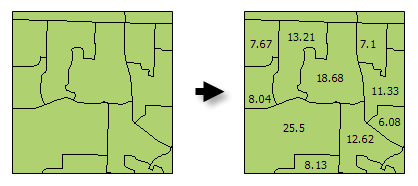
Calculate Areas illustration

使用法

  • The F_AREA field created in the Output Feature Class will be populated with values for the area of each polygon feature in square units of the Output Coordinate System.

  • There are alternative methods for creating an Area field for polygon features including: Calculate Field and the Geometry Calculator.

  • The Output Feature Class is a copy of the Input Feature Class with the additional (or updated) F_AREA field containing polygon areas.

  • 注意:

    The F_AREA field is created in the Output Feature Class to store calculated Area values. If a field of this name already exists in the Input Feature Class, it will be overwritten in the Output Feature Class.

    注意:

    シェープファイルを使用するときは、NULL 値を格納できないため、注意が必要です。シェープファイル以外の入力からシェープファイルを作成するツールまたはその他の方法では、NULL 値がゼロとして格納または解釈される場合があります。場合によっては、NULL 値はシェープファイルに非常に大きな負の値として格納されます。この場合、予期せぬ結果に至ることがあります。詳細については、「ジオプロセシングでのシェープファイル出力の注意事項」をご参照ください。

構文

CalculateAreas(Input_Feature_Class, Output_Feature_Class)
パラメーター説明データ タイプ
Input_Feature_Class

The input polygon feature class.

Feature Layer
Output_Feature_Class

The output feature class. This feature class is a copy of the input feature class with field F_AREA added (or updated). The F_AREA field contains the polygon area.

Feature Class

コードのサンプル

CalculateAreas Example (Python Window)

The following Python Window script demonstrates how to use the CalculateAreas tool.

import arcpy
arcpy.env.workspace = "c:/data"
arcpy.CalculateAreas_stats("tracts.shp", "tracts_with_area_field.shp")
CalculateAreas Example (stand-alone Python script)

The following stand-alone Python script demonstrates how to use the CalculateAreas tool.

# Calculate AREA values
 
# Import system modules
import arcpy
 
# Local variables...
workspace = "C:/data"
input = "tracts.shp"
calculate_output = "tracts_with_area_field.shp"
 
try:
    # Set the current workspace (to avoid having to specify the full path to the feature classes each time)
    arcpy.env.workspace = workspace
 
    # Process: Calculate Areas...
    arcpy.CalculateAreas_stats(input, calculate_output)
 
except:
    # If an error occurred when running the tool, print out the error message.
    print arcpy.GetMessages()

環境

  • 出力座標系
    備考:

    Feature geometry is projected to the Output Coordinate System prior to analysis.

  • 現在のワークスペース
  • テンポラリ ワークスペース
  • 修飾されたフィールド名
  • 出力データに M 値を含む
  • 出力データに Z 値を含む
  • 出力データのデフォルト Z 値

ライセンス情報

  • Basic: はい
  • Standard: はい
  • Advanced: はい

ArcGIS Desktop

  • ホーム
  • ドキュメント
  • サポート

ArcGIS プラットフォーム

  • ArcGIS Online
  • ArcGIS Desktop
  • ArcGIS Enterprise
  • ArcGIS for Developers
  • ArcGIS Solutions
  • ArcGIS Marketplace

Esri について

  • 会社概要
  • 採用情報
  • Esri ブログ
  • ユーザ カンファレンス
  • デベロッパ サミット
Esri
ご意見・ご感想をお寄せください。
Copyright © 2019 Esri. | プライバシー | リーガル