ArcGIS for Desktop

  • ドキュメント
  • 価格
  • サポート

  • My Profile
  • ヘルプ
  • Sign Out
ArcGIS for Desktop

ArcGIS Online

組織のマッピング プラットフォーム

ArcGIS for Desktop

完全なプロ仕様の GIS

ArcGIS for Server

エンタープライズ GIS

ArcGIS for Developers

位置情報利用アプリの開発ツール

ArcGIS Solutions

各種業界向けの無料のテンプレート マップおよびテンプレート アプリケーション

ArcGIS Marketplace

組織で使えるアプリとデータを取得

  • ドキュメント
  • 価格
  • サポート
Esri
  • サイン イン
user
  • マイ プロフィール
  • サイン アウト

ヘルプ

  • ホーム
  • はじめに
  • マップ
  • 解析
  • データ管理
  • ツール
  • その他...

TIN Aspect

3D Analyst のライセンスで利用可能。

  • サマリ
  • 図
  • 使用法
  • 構文
  • コードのサンプル
  • 環境
  • ライセンス情報

サマリ

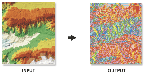
Extracts aspect information from an input TIN into an output feature class.

Produces a polygon feature class whose polygons are categorized by the input TIN's triangle aspect values.

レガシー:

This is a deprecated tool. To learn more about how this tool works click here to view archived documentation. This functionality has been added to the Surface Aspect tool.

図

TIN Aspect illustration

使用法

  • Aspect is expressed in degrees.

構文

TinAspect_3d (in_tin, out_feature_class, {class_breaks_table}, {aspect_field})
パラメータ説明データ タイプ
in_tin

The input TIN.

Tin Layer
out_feature_class

The output feature class.

Feature Class
class_breaks_table
(オプション)

An input table containing the classification breaks that will be used to classify the output feature class.

Table
aspect_field
(オプション)

The field containing aspect values.

String

コードのサンプル

TIN Aspect Example (Python window)

The following Python Window script demonstrates how to use the TIN Aspectfunction in immediate mode.

import arcgisscripting
gp = arcgisscripting.create()

gp.CheckOutExtension("3D")
gp.workspace = "C:/data"
gp.TinAspect_3d("tin", "aspect.shp")

環境

  • 現在のワークスペース
  • 出力データの XY ドメイン
  • 出力データの座標系
  • 範囲
  • テンポラリ ワークスペース
  • XY 座標精度
  • XY 許容値

ライセンス情報

  • ArcGIS for Desktop Basic: 次のものが必要 3D Analyst
  • ArcGIS for Desktop Standard: 次のものが必要 3D Analyst
  • ArcGIS for Desktop Advanced: 次のものが必要 3D Analyst
このトピックへのフィードバック

ArcGIS for Desktop

  • ホーム
  • ドキュメント
  • 価格
  • サポート

ArcGIS プラットフォーム

  • ArcGIS Online
  • ArcGIS for Desktop
  • ArcGIS for Server
  • ArcGIS for Developers
  • ArcGIS Solutions
  • ArcGIS Marketplace

Esri について

  • 会社概要
  • 採用情報
  • スタッフ ブログ
  • ユーザ カンファレンス
  • デベロッパ サミット
Esri
© Copyright 2016 Environmental Systems Research Institute, Inc. | プライバシー | リーガル