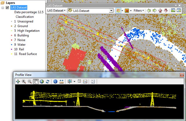
Each and every lidar point in a LAS file can have a classification code set for it. Classifying lidar data allows you to organize mass points into specific data classes while still maintaining them as an entire data collection in LAS files. Typically, these classification codes represent the type of object that has reflected the laser pulse. Point classification is usually completed by data vendors using semi-automated techniques on the point cloud to assign the feature type associated with each point. Lidar points can be classified into a number of categories including bare earth or ground, top of canopy, and water. The different classes are defined using numeric integer codes in the LAS files. The following table contains the LAS classification codes as defined in the LAS 1.4 standard:
| Classification Value | Meaning |
|---|---|
0 | Never classified |
1 | Unassigned |
2 | Ground |
3 | Low Vegetation |
4 | Medium Vegetation |
5 | High Vegetation |
6 | Building |
7 | Low Point |
8 | Reserved * |
9 | Water |
10 | Rail |
11 | Road Surface |
12 | Reserved * |
13 | Wire - Guard (Shield) |
14 | Wire - Conductor (Phase) |
15 | Transmission Tower |
16 | Wire-Structure Connector (Insulator) |
17 | Bridge Deck |
18 | High Noise |
19-63 | Reserved |
64-255 | User Definable |
To learn more about lidar classification, see Lidar point classification.
The LAS dataset provides the ability to display, analyze, and edit the classification codes defined in the LAS files referenced by the LAS dataset. You can perform analytic operations against the classification values.

Displaying LAS class codes
To display the lidar classification codes for a LAS dataset layer, use either the LAS Dataset toolbar or the Layer Properties dialog box in ArcMap or ArcScene.
Displaying classification codes using the LAS Dataset toolbar
From the LAS Dataset toolbar, click the points drop-down menu and choose Class.

Displaying classification codes using the Layer Properties dialog box
- Right-click the LAS dataset layer in the table of contents and click Properties.
- Click the Symbology tab.
- Remove (or uncheck) any existing renderers.
- Click the Add button to open the Add Renderer window.
- Choose the LAS attribute grouped with unique symbol point-based renderer from the list, click Add, and click Dismiss to close the Add Renderer window.
- Click the LAS Attribute button, and choose a different attribute to symbolize the points with.
- Choose the Classification attribute, and click the OK button on the Select LAS Attribute dialog box.
- Click the Add All Values button to load the official list of LAS classification codes.
- Click OK.
Manipulating LAS classification codes
The classification codes in a LAS file can be manipulated using either geoprocessing tools or tools provided on the LAS dataset Profile View window in ArcMap. To learn more about editing classification codes, see Editing LAS point classification.
The following two geoprocessing tools allow you to change the lidar point classification for LAS files referenced by a LAS dataset:
LAS dataset classification editing geoprocessing tools
| Geoprocessing tools | Description |
|---|---|
| Change LAS Class Codes |
Modifies the classification codes for LAS files referenced by a LAS dataset. This tool will completely change one classification code to another, which is particularly useful for updating the classification of LAS files generated prior to the introduction of classification standards in the LAS 1.1 specification. The tool can be used to ensure such data conforms to the current standards. |
| Classify LAS Building | Classifies building rooftop points in aerial lidar data. |
| Classify LAS By Height | Reclassifies lidar points based on their height from the ground surface. |
| Classify LAS Ground | Classifies ground points in lidar data. |
| Classify LAS Noise | Classifies noise points in lidar data. |
| Classify LAS Overlap | Classifies LAS points from overlapping scans. |
| Extract LAS | Extracts LAS files that overlay the clip features or extent. |
| LAS Point Statistics By Area | Evaluates the statistics of LAS points that overlay the area defined by polygon features. |
| LAS Height Metrics | Calculates statistics about the distribution of elevation measurements of vegetation points captured in LAS data. |
| Locate LAS Points By Proximity | Identifies lidar points within the three-dimensional proximity of z-enabled features while also providing the option to reclassify the points and export them to an output feature class. |
| Set LAS Class Codes Using Features |
Changes lidar classification codes assigned to lidar points based on their proximity to feature data. |
You can also use the tools available on the LAS dataset Profile View  window accessed from the LAS Dataset toolbar to edit the classification values interactively.
You can also generate statistics on class codes into reports, or see them in the LAS dataset Properties dialog box. Also, you can create a raster of predominant class codes by location. The following two tools allow you to conduct a statistical analysis on the classification codes:
LAS dataset statistics geoprocessing tools
| Geoprocessing tool | Description |
|---|---|
| LAS Dataset Statistics |
Calculates or updates statistics for a LAS dataset and generates an optional statistics report. |
| LAS Point Statistics As Raster |
Creates a raster storing statistical information about the LAS data points referenced by a LAS dataset. |