The 10.3 release of ArcGIS for Aviation contains new functionality and several enhancements.
New at 10.3.1 patches
Several updates have been made to the Aviation Line Bypass tool, and other tools.
- CartoCommander—Deleted Features Count has now been added to the Results window.
- ICAO Annex 14—A new Take off climb surface has been added to the ICAO Annex 14 obstruction identification surfaces.
- The Update Annotation and Rotate Annotation tools can now be used in an edit session only on selected features.
- Various mapping and performance enhancements and fixes have been made to the AIXM and DAFIF Data Loaders.
- DAFIF—The Digital Aeronautical Flight Information File (DAFIF) shapefiles can now be imported into a geodatabase with the Aeronautical Information System (AIS) schema.
- Line Bypass—An enhancement to the Aviation Line Bypass tool and the Customize Line Bypass tool for improved efficiency, including auto-preview and storing of bypass information.
- The Aviation Line Bypass tool has been enhanced with a new interface where you can create, cut, clear and reset line bypasses with a streamlined process without defining a query.
- Customize Line Bypass is a new tool in the Aviation Editing toolbar that modifies individual line bypasses. You may preview a bypass before committing to a database.
- Route Processing is updated with a check box that allows you to control if you want to run the rules while processing routes.
- The Terrain and Obstacle Profile dialog box allows you to select optional base surfaces when different types of surfaces are created for High or Low ends.
- The GenerateOISProfileJSON function will now add information if an obstacle penetrates the obstruction surface.
- The Primary Surface field has changed to Base Surface in the Terrain and Obstacle Profile dialog box. It may display more than one surface from the obstruction surface layer, but you can only choose one.
- Additional properties have been added for the OIS symbol in the Production Properties dialog box. You can now edit the OIS symbol to change the individual colors for the OIS, label and set the font.
- The Runway Elevation Precision and Elevation Display Limit properties have been added for a runway.
New at 10.3.1
Python
The AviationChartInfo object has been added to the Charting module. It provides access to properties of the product library area of interest (AOI). This object is returned from the GetAviationAOI function. It is an object that contains the information for the map ID, reference scale, spatial reference, rotation angle, geometry, and extraction query properties. The following functions have also been added:
- CreateAirspaceLines—Generates line data from airspace features. You use this data to generate symbology and labels for both sides of the line features.
- CreateAirspaceAreas—Associates vertical (flight level) information from an airspace to two-dimensional features. Labeling these features with vertical information allows the display of three-dimensional information on a two-dimensional chart.
- DeriveAirspaceGeometry—Creates geometry for derived features.
- UpdateAnnotation—Updates annotation for features on specific charts. The features are updated in the existing feature class.
- UpdateTerminalElements—Updates the terminal elements in the chart to reflect changes in the data.
- GetUnqualifiedName—Returns the unqualified name of the dataset sourced to the given input layer.
- GenerateOISProfileJSON—Generates a JSON string that represents the RunwayCenterline, obstruction identification surface (OIS), obstacles, and the elevation along the profile of the approach surface. It was added to the Aviation Airports module.
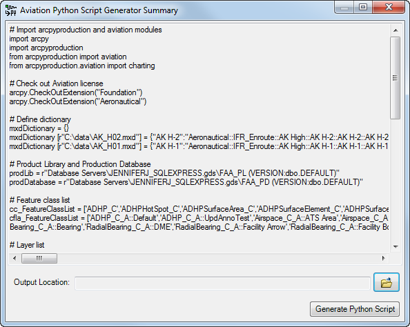
The Aviation Python Script Generator tool has been updated to include the new functions in the Charting Python module, except for UpdateTerminalElements, GetUnqualifiedName, and GenerateOISProfileJSON.
Terminal elements
The following tools were created to generate terminal elements. You can find them on the Customize dialog box.
- Ancillary Information Table—Creates a formatted table containing ancillary terminals information, such as servicing city, runway, and airport identifiers, and primary navaid component information for an airport
- Communication Row—Creates a formatted table containing communication information such as services and frequencies for an airport
- Minima Table—Creates a formatted table containing the minimum descent altitude
- Pilot Briefing Bar—Creates a formatted table containing information for the pilot, such as runway lighting, alternate minimas, and missed approach procedures for an airport
New at 10.3
Airports tools
New tools are available that allow for Aerodrome Mapping Database (AMDB) shapefile import, analysis of an OIS, and generation of a terrain and obstacle profile element.
AMDB-compliant shapefile import
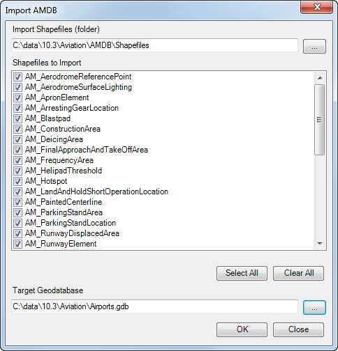
With this release, AMDB specifications such as DO-272C and ED-99C are supported. The Import AMDB Shapefiles To Geodatabase tool allows you to use a cross-reference file to import AMDB-compliant shapefiles into a geodatabase with the Airports schema.

This tool is located on the new Aviation Data Exchange and Aviation Airports toolbars.
On-the-fly obstacle evaluation
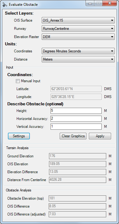
There is now a way to visualize potential obstacle features on a terrain and see how they relate to the OIS. With the Evaluate Obstacle tool you can draw points on the map and view the elevation difference between the OIS and ground level. This can be useful if construction is planned on an existing building and you need to ensure the crane height is not going to interfere with the approach elevation for aircraft.

Terrain and obstacle profile element
The terrain and obstacle profile element provides a view of the runway and approach surfaces as well as any obstructions and terrain that protrude through them.

Changes to the Obstruction Identification Surfaces tool
The following enhancements have been made to the Obstruction Identification Surfaces tool:
- The FAA Advisory Circular 150/5300-13A specification is now supported.
- When TIN is selected as the output, one TIN is created for each surface.
- Multipatch feature classes are supported as an output type.
New Python module
A new Python module has been added to the ArcPyProduction site package that allows you to run chart production processes such as Carto Commander and Create Feature Linked Annotation. You can also import AIXM data into a geodatabase with the Aeronautical Information System (AIS) schema.
The following functions are available at the root level of the Aviation module:
- ImportAixm45—Imports Aeronautical Information Exchange Model (AIXM) 4.5 schema data into an Aeronautical Information System geodatabase
- ImportAixm51—Imports Aeronautical Information Exchange Model (AIXM) 5.1 schema data into an Aeronautical Information System geodatabase
The following functions are available in the charting submodule:
- CartoCommander—Analyzes all the areas of interest maintained in the aviation production database and creates, modifies, and deletes cartographic copies of features. The tool on the Aviation Data Management toolbar and geoprocessing tool of the same name are also available.
- CreateFeatureLinkedAnnotation—Creates annotation for features on specific charts if it does not already exist. If the annotation feature class exists, the features are appended to the existing feature class. The tool on the Aviation Annotation toolbar and geoprocessing tool of the same name are also available.
- GenerateCheckSum—Creates a checksum value from a list of values determined by an organization or specification requirements.
- GetAviationAOI—Retrieves the map ID, reference scale, rotation angle, geometry, and extraction query information for an AOIfeature.
Create a Python script using a wizard
The Aviation Python Script Generator tool allows you to create a Python script that can run up to three processes on the charts you choose. The Carto Commander, Visual Specifications, and Create Feature Linked Annotation processes can be configured to run on the instances and maps you choose. The output of the tool is a Python script that can be used to automate these processes and make your workflow more efficient.

Support for data models
Below are details on the support for data models at this release.
AIS
- The Airports data model includes changes to 18B from FAA.
- AIS now includes the temporality component of AIXM 5.1.
AMDB
In addition to the ability to load data from AMDB-compliant shapefiles using the Import AMDB Shapefiles To Geodatabase tool, there are also Reviewer batch jobs that can be used to validate your data against AMDB specifications.
eTOD
- Expanded data model changes
- Improvements to batch jobs