ArcGIS for Maritime: Charting allows you to define rounding rules that the system will honor during production.
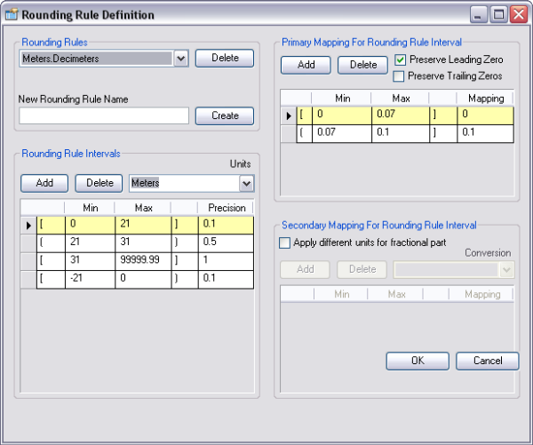
A rounding rule is composed of rounding rule intervals and primary and secondary mappings for each interval.
- Start ArcCatalog.
- Add the Rounding Rule Definition tool to a toolbar by completing the following steps:
- On the main menu, click Customize > Customize Mode.
The Customize dialog box appears.
- Click the Commands tab.
- In the Categories list, choose Nautical.
- In the Commands list, click and drag the Rounding Rule Definition button
 to a toolbar.
- Click Close.
- On the main menu, click Customize > Customize Mode.
- Click the Rounding Rule Definition button
 .
.
The Rounding Rule Definition dialog box appears.

- Type the name of the rounding rule in the New Rounding Rule Name text box.
- Click Create.
- In the Rounding Rule Intervals area, click Add.
- Click the Units drop-down arrow and choose the appropriate units.
- Click the blank table record to define the new rounding rule interval.
- Click the first column and choose the parameter for inclusive or exclusive from the drop-down list.
- [ ]—A bracket includes the value.
- ( )—A parenthesis excludes the value.
- Type a minimum value in the Min text box.
- Type a maximum value in the Max text box.
- Click the fourth column and choose the parameter for inclusive or exclusive from the drop-down list.
- [ ]—A bracket includes the value.
- ( )—A parenthesis excludes the value.
- Type a value in the Precision text box.
- Make sure the correct rounding rule interval is highlighted.
- In the Primary Mapping For Rounding Rule Interval area, click Add.
- Check the appropriate check boxes to preserve leading and/or trailing zeros.
- Click the blank table record to define the new rounding rule interval.
- Choose either a bracket for inclusive or parenthesis for exclusive from the drop-down list.
- Type a minimum value in the Min text box.
- Type a maximum value in the Max text box.
- Choose either a bracket for an inclusive or parenthesis for exclusive from the drop-down list.
- Type a value in the Mapping text box.
- Click OK to close the Rounding Rule Definition dialog box or follow the rest of the steps to create a secondary mapping.
- Make sure the correct rounding rule interval is highlighted.
- In the Secondary Mapping for Rounding Rule Interval area, check the Apply different units for fractional part check box.
- Click Add to add a secondary mapping rounding rule.
- Click the Conversion drop-down arrow and choose a conversion.
- Click the blank table record to define the new rounding rule interval.
- Choose either a bracket for inclusive or parentheses for exclusive from the drop-down list.
- Type a minimum value in the Min text box.
- Type a maximum value in the Max text box.
- Choose either a bracket for inclusive or parentheses for exclusive from the drop-down list.
- Type a value in the Mapping text box.
- Repeat steps 25 through 33 for additional secondary mappings.
- Click OK.
Related topics
- Adding a unit conversion rule
- Deleting a primary or secondary mapping
- Deleting a rounding rule
- Deleting a rounding rule interval
- Editing data using unit conversion
- Labeling data with unit conversion
- Modifying a primary or secondary mapping for the rounding rule interval
- Modifying an existing rounding rule interval
- Unit conversion and rounding rules