ArcGIS for Desktop

  • Documentation
  • Pricing
  • Support

  • My Profile
  • Help
  • Sign Out
ArcGIS for Desktop

ArcGIS Online

The mapping platform for your organization

ArcGIS for Desktop

A complete professional GIS

ArcGIS for Server

GIS in your enterprise

ArcGIS for Developers

Tools to build location-aware apps

ArcGIS Solutions

Free template maps and apps for your industry

ArcGIS Marketplace

Get apps and data for your organization

  • Documentation
  • Pricing
  • Support
Esri
  • Sign In
user
  • My Profile
  • Sign Out

Help

  • Home
  • Get Started
  • Map
  • Analyze
  • Manage Data
  • Tools
  • More...

Threshold areas

  • Overview
  • Input Prerequisites
  • Example Output

Overview

Threshold areas create polygons around your stores. The radius of the polygon is determined by expanding from the store location until it meets your criteria. The polygons can be concentric rings or drive-time areas.

You can choose any layer and any field in that layer to use in creating rings. Typically, the Block Points layer is used. It contains population, households, housing units, and business counts. You can also use any of the Business Analyst Datasources, such as block groups, or even your own data as part of a BDS layer. Business Analyst automatically uses block point data aggregation to more accurately define the threshold areas.

Input Prerequisites

Any point file or files.

Example Output

The images below displays rings drawn when a 150,000 and 300,000 population threshold is reached. Both simple rings and drive times are used to retrieve the population statistics from the same site. The simple ring method represented in the image below uses a Euclidean distance outward from the starting site.
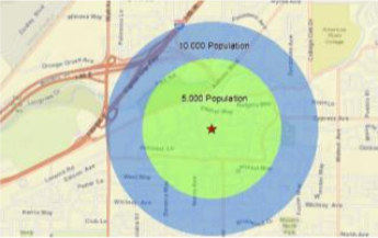
Threshold areas - simple rings

The drive-time method represented in the image below traverses the underlying streets database working outward until the criteria are satisfied.
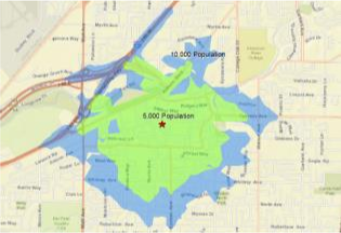
Threshold areas - drive times
Note:

The drive-time option is processing intensive in comparison to the simple rings.

Learn more about Threshold Areas.

Feedback on this topic?

ArcGIS for Desktop

  • Home
  • Documentation
  • Pricing
  • Support

ArcGIS Platform

  • ArcGIS Online
  • ArcGIS for Desktop
  • ArcGIS for Server
  • ArcGIS for Developers
  • ArcGIS Solutions
  • ArcGIS Marketplace

About Esri

  • About Us
  • Careers
  • Insiders Blog
  • User Conference
  • Developer Summit
Esri
© Copyright 2016 Environmental Systems Research Institute, Inc. | Privacy | Legal