The Remove Trade Area Overlap tool removes cannibalization between trade areas generated in Business Analyst or custom derived trade areas. Overlap is removed using Thiessen polygons or a grid based approach to find the midpoint between the intersecting areas.
Remove Overlap Methodology
Assume you have two trade area polygons that have an intersection.
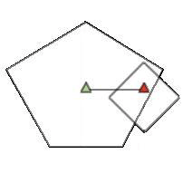
In the example below, the area highlighted light blue represents the overlap area. The two triangle symbols represent the stores for each trade area.
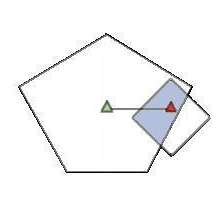
The Remove Trade Area Overlap function in Business Analyst is based on the assumption that overlap is only removed by dividing the intersection area. The tool does not assign areas that are not overlapped to other stores. In the example above, only the area that is shaded blue will be affected by the Remove Trade Area Overlap tool.
There are two approaches for removing overlap:
Method 1 - Thiessen Polygon
The Thiessen polygon approach removes overlap between two or more trade areas using straight lines to divide the area of overlap. This approach uses a series of geometric functions to create nonoverlapping trade areas. First, a line is drawn between each store and neighboring store.
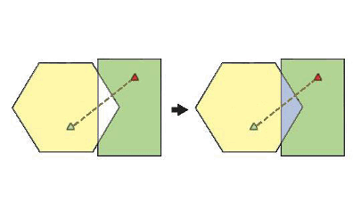
Second, a perpendicular line is drawn bisecting the line drawn between the stores at a right angle. The dotted line below is drawn at the midpoint between the two store locations and represents the division between the two trade areas.
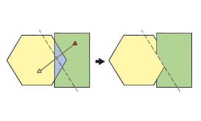
Method 2 - Grid
The grid approach takes into account weights of the stores and shape of the overlapping polygon to make the division more natural.
The grid approach uses a series of geometric functions to create nonoverlapping trade areas. First, a line is drawn between each store and neighboring store. Second, two parallel lines are drawn that pass through the stores that are perpendicular to the line drawn between the stores. The red shaded area below illustrates the target area of intersection. This area is determined by finding the area of overlap between the two trade areas contained between the two perpendicular lines.
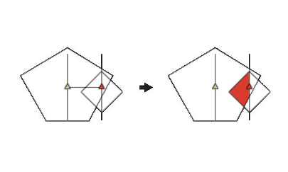
After determining the area of intersection, a grid is created by drawing parallel lines between the two stores. A simplified example is illustrated below.
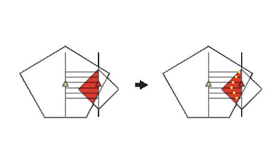
Intersection points are then determined within the red area so each grid line can be divided into nonoverlapping trade areas. The yellow points above illustrate how the midpoints are determined. These points are connected to represent the division between the overlapping trade areas.
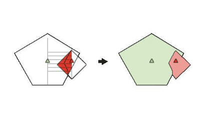
In the grid approach, there are three different methods for determining where to draw the intersection line. These three methods determine how the midpoints are used to draw a line between the two polygons to remove overlap. Specifically, these three methods determine where the yellow dots are placed to create the nonoverlapping line between the two trade areas.
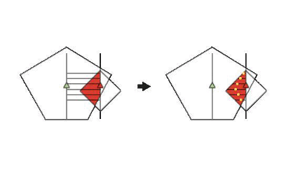
- Use weight field - The weight method uses a numeric weight field you specify to determine the location of the midpoints. In the illustration above, the ratio between the two trade area weights is used to divide the parallel grid lines in the area of intersection. For example, you could use the ratio of the size of each store (gross leasable area or square footage) to determine where to draw the area of overlap. If the green store is larger than the red store, the yellow dots will move to the right and the resulting green trade area will be larger.
- Use area of trade area as weights - If you do not have numeric attribute data to determine the weights, you can use the area of the trade areas to determine the location of the midpoints. In the illustration above, the ratio between the area of the two trade areas is used to divide the parallel grid lines in the area of intersection. This method assumes that larger trade areas will have more influence in a particular market. For example, the green store's trade area is larger, and the yellow dots will move to the right.
- Use the actual midpoint of the intersecting grid line - In this method, the midpoints are placed so the grid lines are divided equally in the red shaded area. The geometric midpoint is determined by measuring the length of each parallel grid line and dividing each line equally between the stores.