ArcGIS Desktop

  • ArcGIS Pro
  • ArcMap

  • My Profile
  • Help
  • Sign Out
ArcGIS Desktop

ArcGIS Online

The mapping platform for your organization

ArcGIS Desktop

A complete professional GIS

ArcGIS Enterprise

GIS in your enterprise

ArcGIS Developers

Tools to build location-aware apps

ArcGIS Solutions

Free template maps and apps for your industry

ArcGIS Marketplace

Get apps and data for your organization

  • Documentation
  • Support
Esri
  • Sign In
user
  • My Profile
  • Sign Out

ArcMap

  • Home
  • Get Started
  • Map
  • Analyze
  • Manage Data
  • Tools
  • Extensions

A quick tour of ArcGIS Maritime

  • Nautical toolbox
  • ArcGIS Maritime toolbars

This topic contains a high-level overview of the user interfaces and capabilities that are added to ArcGIS Desktop after installing ArcGIS Maritime and enabling the ArcGIS Maritime extension on the Extensions dialog box.

Nautical toolbox

ArcGIS Maritime includes a number of geoprocessing tools for all aspects of maritime raster and vector chart maintenance, production, visualization and validation.
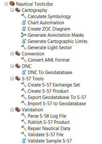
tools

Cartography

The Cartography toolset provides the tools used to generate a paper nautical chart. These tools allow you to generate cartographic data for your charts.

  • Calculate Symbology
  • Chart Automation
  • Create ZOC Diagram
  • Generate Annotation Masks
  • Generate Cartographic Limits
  • Generate Light Sector

Conversion Tools

The Conversion toolset provides tools that can be used to convert maritime data formats. These tools allow you to change target AML versions between 1.0 and 2.1.

  • Convert AML Format

DNC

The ArcGIS Maritime toolbox's DNC toolset provides a tool that imports Digital Nautical Chart (DNC) data into an enterprise geodatabase, the DNC NIS.

  • DNC To Geodatabase

S-57 Tools

The S-57 Tools toolset provides tools that allow you to create, import and export S-57 data.

  • Create S-57 Exchange Set
  • Create S-57 Product
  • Export Geodatabase To S-57
  • Import S-57 To Geodatabase

Validation

The Validation toolset provides tools that allow support data validation, maintenance and publication.

  • Parse S-58 Log File
  • Publish S-57 Product
  • Repair Nautical Data
  • Validate S-57 File
  • Validate Sample S-57

ArcGIS Maritime toolbars

ArcGIS Maritime comes with a variety of toolbars designed to support the production and use of various maritime standards.

Nautical toolbar

The Nautical toolbar contains tools and functionality that facilitate the maintenance and production of S-57 data.

Nautical toolbar
  • Advanced SQL Calculator
  • Batch Copy Paste
  • Relationship Manager
  • Track Deletes
  • Apply Changes
  • Select Unverified Features
  • Verify Selected Features
  • Reconcile
  • Nautical Post
  • Compilation Scale
  • Generate QC Cell
    • Generate QC Cell (Graphic)
    • Generate QC Cell (Selected Polygon Feature)
  • Checkout Nautical Replica
  • Synchronize Changes

Nautical Cartography toolbar

The Nautical Cartography toolbar provides quick access to grid, geoprocessing and layout editing tools.

Nautical Cartography toolbar
  • Grids:
    • Grid Layout View
    • Add Grid Data
    • Grids and Graticules Designer
    • Make Grids and Graticules Layer
  • Geoprocessing:
    • Generate Light Sector
    • Generate Cartographic Limits
    • Generate Annotation Masks
    • Magnetic Calculator
  • Graphic Table Element
  • Database Element
  • INT2 Scale Bar
  • Measure Layout

Nautical Editing Cartography toolbar

Nautical Editing Cartography toolbar
  • Free Representation
  • Select Tool
  • Direct Select Tool
  • Insert Control Point
  • Delete Control Point
  • Rotate Tool
  • Move Tool
  • Reshape Representation Tool
  • Representation Properties
  • Edit Annotation Tool
  • Displace Depth Annotation
  • Edit Light Sector

Nautical BSB toolbar

The Nautical BSB toolbar contains tools that support the creation and maintenance of BSB links and notes for the BSB export format.

Nautical BSB toolbar

  • Create BSB Links
  • Find BSB Note Or Links
  • Toggle BSB Links

Nautical DNC toolbar

Nautical DNC toolbar
  • Create Dqyarea
  • Notes Editor
  • Units Conversion
  • Label SoundP Layers
  • Label BotcharP Layers
  • Group Layers By Theme
  • Notice To Mariners
  • NTM Parser
  • Convert GDB To VPF

ArcGIS Desktop

  • Home
  • Documentation
  • Support

ArcGIS

  • ArcGIS Online
  • ArcGIS Desktop
  • ArcGIS Enterprise
  • ArcGIS
  • ArcGIS Developer
  • ArcGIS Solutions
  • ArcGIS Marketplace

About Esri

  • About Us
  • Careers
  • Esri Blog
  • User Conference
  • Developer Summit
Esri
Tell us what you think.
Copyright © 2021 Esri. | Privacy | Legal