Available with 3D Analyst license.
Terrain pyramids can require a significant amount of storage space. The size is roughly equivalent to that of the geometry present in the feature classes participating in the terrain. For large point collections, typically represented by lidar or sonar, the cost may be prohibitive. In these cases, large multipoint feature classes can be embedded in a terrain dataset as a way to save storage space.
When a multipoint feature class is embedded, its geometry and, optionally, LAS lidar attributes are copied directly into the terrain pyramid structure. This copying occurs during the build process. After the terrain is built, it becomes the container of the points and no longer references the source feature class. That feature class can be deleted, allowing you to recover its storage space. Keep in mind that subsequent builds involving schema edits will temporarily require roughly that amount of space for processing.
Benefits associated with embedded data:
- The source point feature class can be deleted, saving storage space on disk.
- Embedding points allow access to the point attribute information for analysis, display, and editing.
- Terrain editing operations (append, delete, and replace) all handle point attributes.
- Embedding points can take advantage of point attribute symbology renderers.
- The embedded points can be used by the terrain point profile tool.
- When using the terrain point profile tool the point attribute are accessed for display.
Limitations associated with embedded data:
- Access to embedded feature classes is restricted. You won't see them listed in ArcCatalog.
- Only LAS lidar attributes can be included. Other attributes are not carried over. Access to the lidar attributes is limited.
- Editing of embedded feature classes can only be accomplished with terrain-specific geoprocessing tools.
- Once the feature class is embedded, it's not available for use by another terrain.
- Reconciling conflicts of embedded data in a versioned database works differently than with regular data sources.
Whether these trade-offs represent a significant issue depends on the requirements of your project. Weigh them against storage costs to determine whether you should use embedding.
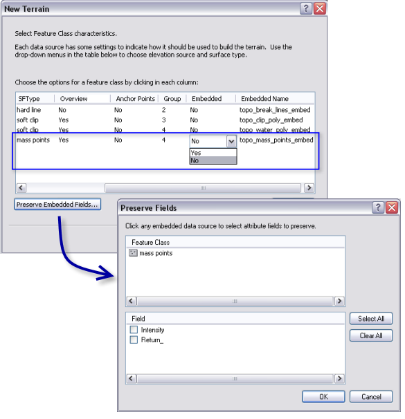
In the New Terrain wizard, a multipoint feature class can be set as embedded in the Select Feature Class characteristics area on the New Terrain dialog box as shown in the following example:

The Preserve Embedded Fields button is enabled if there are feature classes that are to be embedded in the terrain dataset. For example, lidar points contain per point attributes, such as intensity and return number, which can be saved along side the embedded points. Select the Preserve Embedded Fields button if you want select attributes to be saved along side the embedded points.